You are here: Home > Network List > TA - USArray Transportable Network (new EarthScope stations) Stations List
> Station R52A Catlettsburg, KY, USA > Earthquake Result Viewer
R52A Catlettsburg, KY, USA - Earthquake Result Viewer
| Earthquake location: |
Eastern Siberia, Russia |
| Earthquake latitude/longitude: |
67.6/142.5 |
| Earthquake time(UTC): |
2013/02/14 (045) 13:13:53 GMT |
| Earthquake Depth: |
11 km |
| Earthquake Magnitude: |
6.5 MB, 6.7 MS, 6.6 MW, 6.7 MW |
| Earthquake Catalog/Contributor: |
WHDF/NEIC |
|
| Network: |
TA USArray Transportable Network (new EarthScope stations) |
| Station: |
R52A Catlettsburg, KY, USA |
| Lat/Lon: |
38.34 N/82.64 W |
| Elevation: |
300 m |
|
| Distance: |
69.0 deg |
| Az: |
36.671 deg |
| Baz: |
343.101 deg |
| Ray Param: |
0.055935416 |
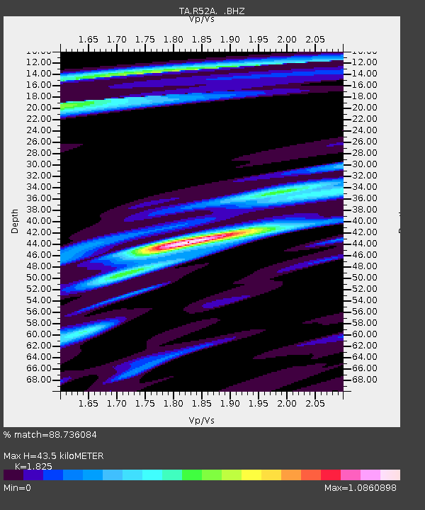
| Estimated Moho Depth: |
43.5 km |
| Estimated Crust Vp/Vs: |
1.83 |
| Assumed Crust Vp: |
6.232 km/s |
| Estimated Crust Vs: |
3.415 km/s |
| Estimated Crust Poisson's Ratio: |
0.29 |
|
| Radial Match: |
88.736084 % |
| Radial Bump: |
372 |
| Transverse Match: |
74.24639 % |
| Transverse Bump: |
400 |
| SOD ConfigId: |
494114 |
| Insert Time: |
2013-05-04 06:14:34.060 +0000 |
| GWidth: |
2.5 |
| Max Bumps: |
400 |
| Tol: |
0.001 |
|

Signal To Noise
| Channel | StoN | STA | LTA |
| TA:R52A: :BHZ:20130214T13:24:27.224971Z | 5.8889923 | 2.8559828E-6 | 4.8496963E-7 |
| TA:R52A: :BHN:20130214T13:24:27.224971Z | 2.2213297 | 1.174091E-6 | 5.2855324E-7 |
| TA:R52A: :BHE:20130214T13:24:27.224971Z | 1.3054287 | 5.926322E-7 | 4.5397513E-7 |
| Arrivals |
| Ps | 6.0 SECOND |
| PpPs | 19 SECOND |
| PsPs/PpSs | 25 SECOND |


