You are here: Home > Network List > GT - Global Telemetered Seismograph Network (USAF/USGS) Stations List
> Station CPUP Villa Florida, Paraguay > Earthquake Result Viewer
CPUP Villa Florida, Paraguay - Earthquake Result Viewer

| Earthquake location: |
Colombia |
| Earthquake latitude/longitude: |
5.1/-75.7 |
| Earthquake time(UTC): |
1995/08/19 (231) 21:43:32 GMT |
| Earthquake Depth: |
125 km |
| Earthquake Magnitude: |
6.1 MB, 6.6 UNKNOWN, 6.5 MW |
| Earthquake Catalog/Contributor: |
WHDF/NEIC |
|
| Network: |
GT Global Telemetered Seismograph Network (USAF/USGS) |
| Station: |
CPUP Villa Florida, Paraguay |
| Lat/Lon: |
26.33 S/57.33 W |
| Elevation: |
105 m |
|
| Distance: |
36.0 deg |
| Az: |
151.22 deg |
| Baz: |
327.698 deg |
| Ray Param: |
0.07652189 |
| Estimated Moho Depth: |
33.25 km |
| Estimated Crust Vp/Vs: |
1.75 |
| Assumed Crust Vp: |
6.498 km/s |
| Estimated Crust Vs: |
3.724 km/s |
| Estimated Crust Poisson's Ratio: |
0.26 |
|
| Radial Match: |
95.05061 % |
| Radial Bump: |
188 |
| Transverse Match: |
90.07168 % |
| Transverse Bump: |
297 |
| SOD ConfigId: |
6273 |
| Insert Time: |
2010-02-27 01:49:32.463 +0000 |
| GWidth: |
2.5 |
| Max Bumps: |
400 |
| Tol: |
0.001 |
|
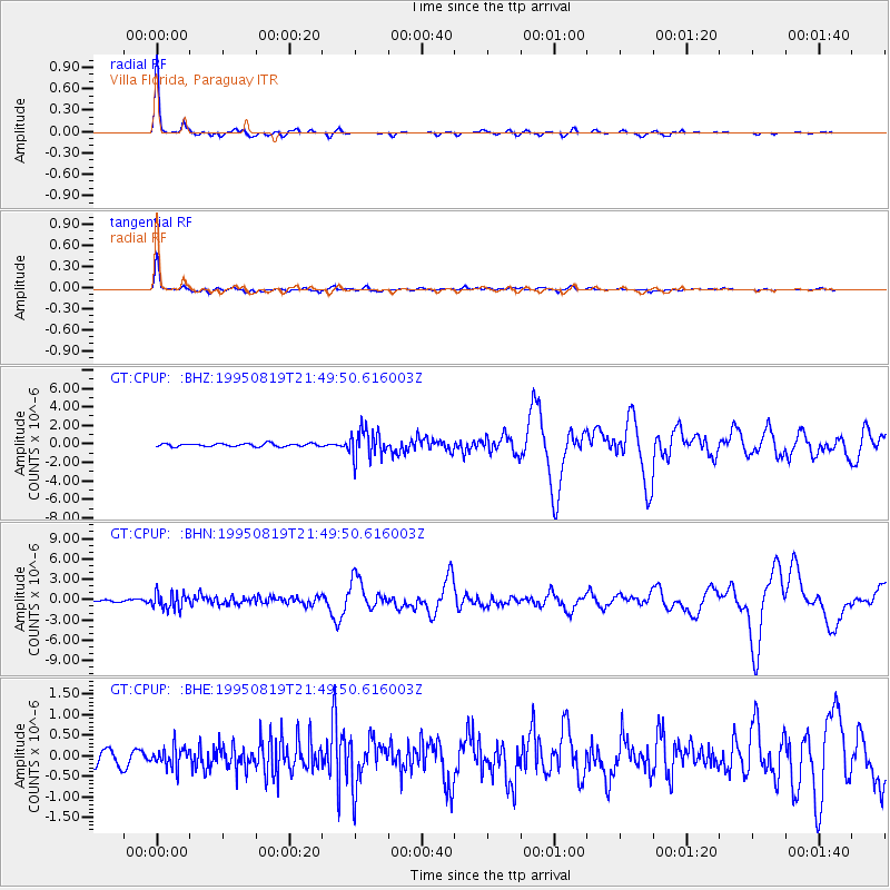
Signal To Noise
| Channel | StoN | STA | LTA |
| GT:CPUP: :BHN:19950819T21:49:50.616003Z | 6.678254 | 1.2171122E-6 | 1.8225005E-7 |
| GT:CPUP: :BHE:19950819T21:49:50.616003Z | 1.3018688 | 2.457824E-7 | 1.8879199E-7 |
| GT:CPUP: :BHZ:19950819T21:49:50.616003Z | 9.315032 | 1.5192662E-6 | 1.6309833E-7 |
| Arrivals |
| Ps | 4.1 SECOND |
| PpPs | 13 SECOND |
| PsPs/PpSs | 17 SECOND |


