You are here: Home > Network List > TA - USArray Transportable Network (new EarthScope stations) Stations List
> Station E47A Iron Bridge, ON, CAN > Earthquake Result Viewer
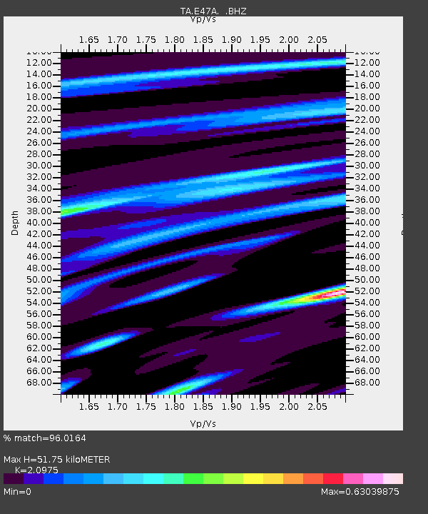
E47A Iron Bridge, ON, CAN - Earthquake Result Viewer
| Earthquake location: |
Eastern Siberia, Russia |
| Earthquake latitude/longitude: |
67.6/142.5 |
| Earthquake time(UTC): |
2013/02/14 (045) 13:13:53 GMT |
| Earthquake Depth: |
11 km |
| Earthquake Magnitude: |
6.5 MB, 6.7 MS, 6.6 MW, 6.7 MW |
| Earthquake Catalog/Contributor: |
WHDF/NEIC |
|
| Network: |
TA USArray Transportable Network (new EarthScope stations) |
| Station: |
E47A Iron Bridge, ON, CAN |
| Lat/Lon: |
46.45 N/83.28 W |
| Elevation: |
246 m |
|
| Distance: |
61.1 deg |
| Az: |
34.464 deg |
| Baz: |
341.742 deg |
| Ray Param: |
0.061078515 |
| Estimated Moho Depth: |
51.75 km |
| Estimated Crust Vp/Vs: |
2.10 |
| Assumed Crust Vp: |
6.467 km/s |
| Estimated Crust Vs: |
3.083 km/s |
| Estimated Crust Poisson's Ratio: |
0.35 |
|
| Radial Match: |
96.0164 % |
| Radial Bump: |
261 |
| Transverse Match: |
73.67387 % |
| Transverse Bump: |
400 |
| SOD ConfigId: |
494114 |
| Insert Time: |
2013-05-04 06:18:51.503 +0000 |
| GWidth: |
2.5 |
| Max Bumps: |
400 |
| Tol: |
0.001 |
|

Signal To Noise
| Channel | StoN | STA | LTA |
| TA:E47A: :BHZ:20130214T13:23:36.15002Z | 6.0011873 | 2.9465418E-6 | 4.9099316E-7 |
| TA:E47A: :BHN:20130214T13:23:36.15002Z | 4.086006 | 1.2287136E-6 | 3.0071263E-7 |
| TA:E47A: :BHE:20130214T13:23:36.15002Z | 1.6231731 | 4.7685666E-7 | 2.9378052E-7 |
| Arrivals |
| Ps | 9.1 SECOND |
| PpPs | 24 SECOND |
| PsPs/PpSs | 33 SECOND |


