You are here: Home > Network List > TA - USArray Transportable Network (new EarthScope stations) Stations List
> Station R55A Marlinton, WV, USA > Earthquake Result Viewer
R55A Marlinton, WV, USA - Earthquake Result Viewer
| Earthquake location: |
Eastern Siberia, Russia |
| Earthquake latitude/longitude: |
67.6/142.5 |
| Earthquake time(UTC): |
2013/02/14 (045) 13:13:53 GMT |
| Earthquake Depth: |
11 km |
| Earthquake Magnitude: |
6.5 MB, 6.7 MS, 6.6 MW, 6.7 MW |
| Earthquake Catalog/Contributor: |
WHDF/NEIC |
|
| Network: |
TA USArray Transportable Network (new EarthScope stations) |
| Station: |
R55A Marlinton, WV, USA |
| Lat/Lon: |
38.28 N/80.12 W |
| Elevation: |
833 m |
|
| Distance: |
69.6 deg |
| Az: |
34.651 deg |
| Baz: |
343.946 deg |
| Ray Param: |
0.055529084 |
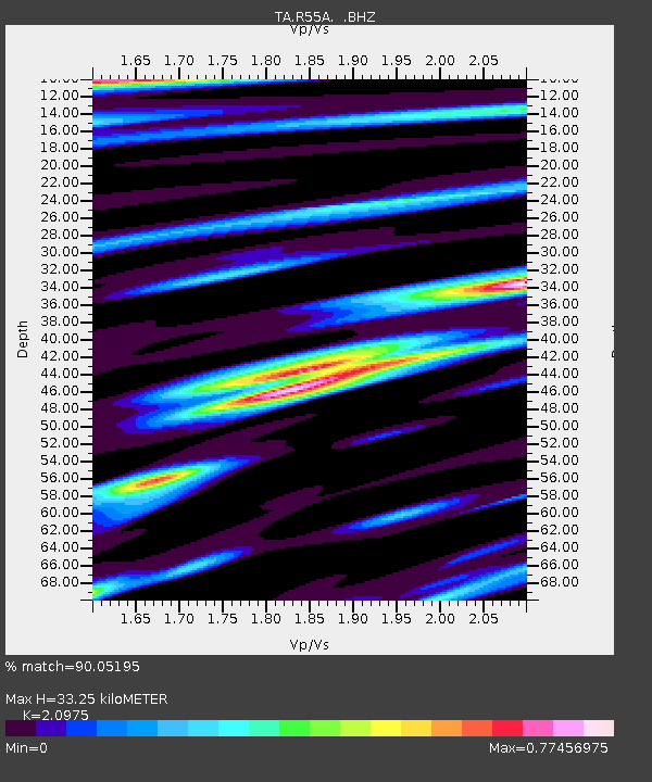
| Estimated Moho Depth: |
33.25 km |
| Estimated Crust Vp/Vs: |
2.10 |
| Assumed Crust Vp: |
6.207 km/s |
| Estimated Crust Vs: |
2.959 km/s |
| Estimated Crust Poisson's Ratio: |
0.35 |
|
| Radial Match: |
90.05195 % |
| Radial Bump: |
400 |
| Transverse Match: |
75.82595 % |
| Transverse Bump: |
400 |
| SOD ConfigId: |
494114 |
| Insert Time: |
2013-05-04 06:21:54.291 +0000 |
| GWidth: |
2.5 |
| Max Bumps: |
400 |
| Tol: |
0.001 |
|

Signal To Noise
| Channel | StoN | STA | LTA |
| TA:R55A: :BHZ:20130214T13:24:31.02502Z | 5.2231197 | 2.2279344E-6 | 4.2655242E-7 |
| TA:R55A: :BHN:20130214T13:24:31.02502Z | 2.4221947 | 9.693402E-7 | 4.0019088E-7 |
| TA:R55A: :BHE:20130214T13:24:31.02502Z | 1.7165132 | 5.5413506E-7 | 3.22826E-7 |
| Arrivals |
| Ps | 6.1 SECOND |
| PpPs | 16 SECOND |
| PsPs/PpSs | 22 SECOND |


