You are here: Home > Network List > UW - Pacific Northwest Regional Seismic Network Stations List
> Station UMAT Pilot Rock, OR, USA > Earthquake Result Viewer
UMAT Pilot Rock, OR, USA - Earthquake Result Viewer
| Earthquake location: |
Eastern Siberia, Russia |
| Earthquake latitude/longitude: |
67.6/142.5 |
| Earthquake time(UTC): |
2013/02/14 (045) 13:13:53 GMT |
| Earthquake Depth: |
11 km |
| Earthquake Magnitude: |
6.5 MB, 6.7 MS, 6.6 MW, 6.7 MW |
| Earthquake Catalog/Contributor: |
WHDF/NEIC |
|
| Network: |
UW Pacific Northwest Regional Seismic Network |
| Station: |
UMAT Pilot Rock, OR, USA |
| Lat/Lon: |
45.29 N/118.96 W |
| Elevation: |
1318 m |
|
| Distance: |
52.1 deg |
| Az: |
62.212 deg |
| Baz: |
331.334 deg |
| Ray Param: |
0.06697397 |
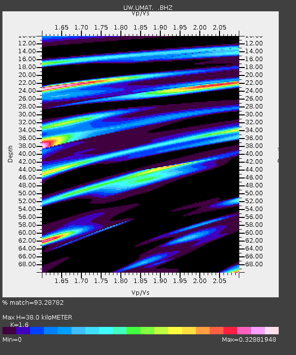
| Estimated Moho Depth: |
38.0 km |
| Estimated Crust Vp/Vs: |
1.60 |
| Assumed Crust Vp: |
6.571 km/s |
| Estimated Crust Vs: |
4.107 km/s |
| Estimated Crust Poisson's Ratio: |
0.18 |
|
| Radial Match: |
93.28782 % |
| Radial Bump: |
286 |
| Transverse Match: |
90.54076 % |
| Transverse Bump: |
400 |
| SOD ConfigId: |
494114 |
| Insert Time: |
2013-05-04 06:24:24.980 +0000 |
| GWidth: |
2.5 |
| Max Bumps: |
400 |
| Tol: |
0.001 |
|

Signal To Noise
| Channel | StoN | STA | LTA |
| UW:UMAT: :BHZ:20130214T13:22:32.099971Z | 12.365783 | 1.6713218E-6 | 1.3515698E-7 |
| UW:UMAT: :BHN:20130214T13:22:32.099971Z | 4.401303 | 8.357642E-7 | 1.8989017E-7 |
| UW:UMAT: :BHE:20130214T13:22:32.099971Z | 2.7829316 | 5.2306893E-7 | 1.8795608E-7 |
| Arrivals |
| Ps | 3.7 SECOND |
| PpPs | 14 SECOND |
| PsPs/PpSs | 18 SECOND |


