You are here: Home > Network List > AK - Alaska Regional Network Stations List
> Station MDM Murphy Dome > Earthquake Result Viewer
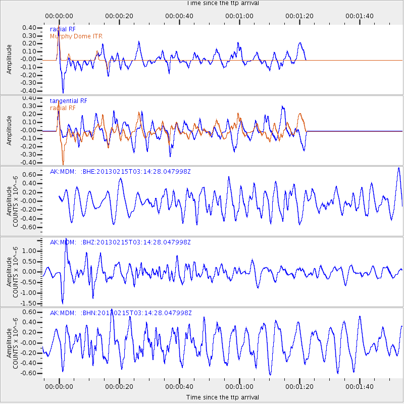
MDM Murphy Dome - Earthquake Result Viewer
*The percent match for this event was below the threshold and hence no stack was calculated.
| Earthquake location: |
Tonga Islands |
| Earthquake latitude/longitude: |
-19.7/-174.5 |
| Earthquake time(UTC): |
2013/02/15 (046) 03:02:23 GMT |
| Earthquake Depth: |
74 km |
| Earthquake Magnitude: |
5.8 MB, 5.7 MW, 5.8 MW |
| Earthquake Catalog/Contributor: |
WHDF/NEIC |
|
| Network: |
AK Alaska Regional Network |
| Station: |
MDM Murphy Dome |
| Lat/Lon: |
64.96 N/148.23 W |
| Elevation: |
634 m |
|
| Distance: |
86.8 deg |
| Az: |
10.862 deg |
| Baz: |
204.651 deg |
| Ray Param: |
$rayparam |
*The percent match for this event was below the threshold and hence was not used in the summary stack. |
|
| Radial Match: |
70.58445 % |
| Radial Bump: |
386 |
| Transverse Match: |
66.3253 % |
| Transverse Bump: |
374 |
| SOD ConfigId: |
494114 |
| Insert Time: |
2013-05-04 06:28:14.695 +0000 |
| GWidth: |
2.5 |
| Max Bumps: |
400 |
| Tol: |
0.001 |
|
Signal To Noise
| Channel | StoN | STA | LTA |
| AK:MDM: :BHZ:20130215T03:14:28.047998Z | 3.6177833 | 7.189577E-7 | 1.987288E-7 |
| AK:MDM: :BHN:20130215T03:14:28.047998Z | 1.031242 | 2.493225E-7 | 2.417692E-7 |
| AK:MDM: :BHE:20130215T03:14:28.047998Z | 0.43630892 | 1.0697187E-7 | 2.4517462E-7 |
| Arrivals |
| Ps | |
| PpPs | |
| PsPs/PpSs | |


