You are here: Home > Network List > TA - USArray Transportable Network (new EarthScope stations) Stations List
> Station P60A Greenville, DE, USA > Earthquake Result Viewer
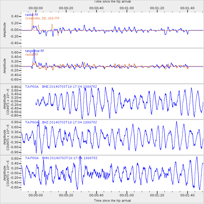
P60A Greenville, DE, USA - Earthquake Result Viewer
*The percent match for this event was below the threshold and hence no stack was calculated.
| Earthquake location: |
Rat Islands, Aleutian Islands |
| Earthquake latitude/longitude: |
52.1/178.5 |
| Earthquake time(UTC): |
2014/07/03 (184) 19:06:47 GMT |
| Earthquake Depth: |
104 km |
| Earthquake Magnitude: |
5.7 MWB, 5.6 MI |
| Earthquake Catalog/Contributor: |
NEIC PDE/NEIC COMCAT |
|
| Network: |
TA USArray Transportable Network (new EarthScope stations) |
| Station: |
P60A Greenville, DE, USA |
| Lat/Lon: |
39.81 N/75.64 W |
| Elevation: |
105 m |
|
| Distance: |
68.2 deg |
| Az: |
52.927 deg |
| Baz: |
320.255 deg |
| Ray Param: |
$rayparam |
*The percent match for this event was below the threshold and hence was not used in the summary stack. |
|
| Radial Match: |
39.67748 % |
| Radial Bump: |
400 |
| Transverse Match: |
74.71618 % |
| Transverse Bump: |
400 |
| SOD ConfigId: |
3390531 |
| Insert Time: |
2019-04-12 16:17:53.783 +0000 |
| GWidth: |
2.5 |
| Max Bumps: |
400 |
| Tol: |
0.001 |
|
Signal To Noise
| Channel | StoN | STA | LTA |
| TA:P60A: :BHZ:20140703T19:17:04.199976Z | 1.4424511 | 6.203325E-7 | 4.3005443E-7 |
| TA:P60A: :BHN:20140703T19:17:04.199976Z | 0.78951496 | 2.4616162E-7 | 3.117884E-7 |
| TA:P60A: :BHE:20140703T19:17:04.199976Z | 1.7797657 | 5.5222415E-7 | 3.1027912E-7 |
| Arrivals |
| Ps | |
| PpPs | |
| PsPs/PpSs | |


