You are here: Home > Network List > TA - USArray Transportable Network (new EarthScope stations) Stations List
> Station V58A Windy Hill, Pittsboro, NC, USA > Earthquake Result Viewer
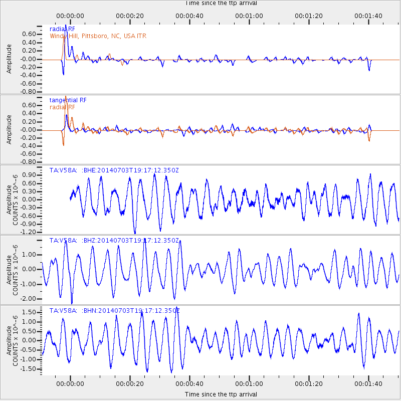
V58A Windy Hill, Pittsboro, NC, USA - Earthquake Result Viewer
| Earthquake location: |
Rat Islands, Aleutian Islands |
| Earthquake latitude/longitude: |
52.1/178.5 |
| Earthquake time(UTC): |
2014/07/03 (184) 19:06:47 GMT |
| Earthquake Depth: |
104 km |
| Earthquake Magnitude: |
5.7 MWB, 5.6 MI |
| Earthquake Catalog/Contributor: |
NEIC PDE/NEIC COMCAT |
|
| Network: |
TA USArray Transportable Network (new EarthScope stations) |
| Station: |
V58A Windy Hill, Pittsboro, NC, USA |
| Lat/Lon: |
35.79 N/79.11 W |
| Elevation: |
127 m |
|
| Distance: |
69.5 deg |
| Az: |
57.952 deg |
| Baz: |
319.944 deg |
| Ray Param: |
0.055337977 |
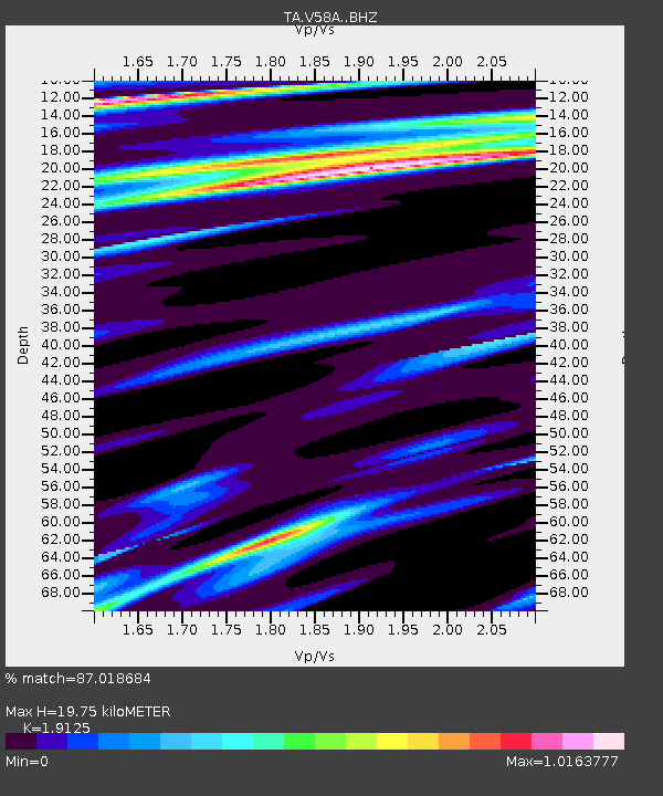
| Estimated Moho Depth: |
19.75 km |
| Estimated Crust Vp/Vs: |
1.91 |
| Assumed Crust Vp: |
6.565 km/s |
| Estimated Crust Vs: |
3.432 km/s |
| Estimated Crust Poisson's Ratio: |
0.31 |
|
| Radial Match: |
87.018684 % |
| Radial Bump: |
400 |
| Transverse Match: |
70.18305 % |
| Transverse Bump: |
373 |
| SOD ConfigId: |
3390531 |
| Insert Time: |
2019-04-12 16:18:04.130 +0000 |
| GWidth: |
2.5 |
| Max Bumps: |
400 |
| Tol: |
0.001 |
|
Signal To Noise
| Channel | StoN | STA | LTA |
| TA:V58A: :BHZ:20140703T19:17:12.350Z | 2.1191902 | 9.384962E-7 | 4.4285605E-7 |
| TA:V58A: :BHN:20140703T19:17:12.350Z | 1.7164017 | 6.2318634E-7 | 3.6307722E-7 |
| TA:V58A: :BHE:20140703T19:17:12.350Z | 1.0480733 | 5.1476707E-7 | 4.911556E-7 |
| Arrivals |
| Ps | 2.8 SECOND |
| PpPs | 8.5 SECOND |
| PsPs/PpSs | 11 SECOND |


