You are here: Home > Network List > CI - Caltech Regional Seismic Network Stations List
> Station SWS Sam W. Stewart, Westmorland, CA, USA > Earthquake Result Viewer
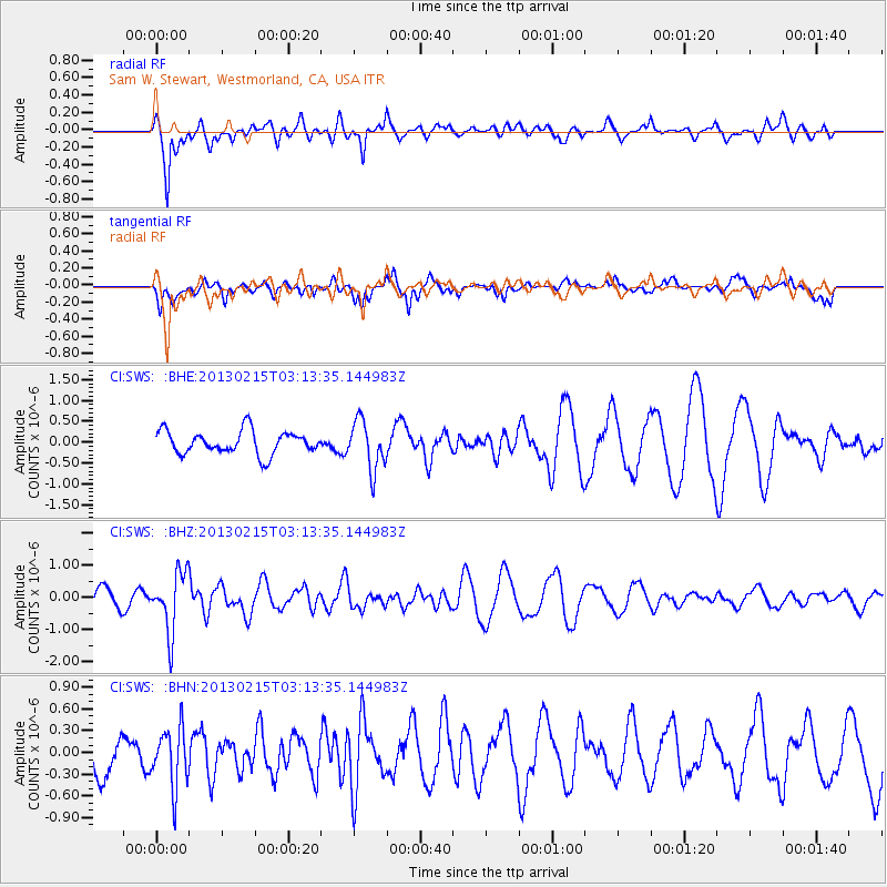
SWS Sam W. Stewart, Westmorland, CA, USA - Earthquake Result Viewer
*The percent match for this event was below the threshold and hence no stack was calculated.
| Earthquake location: |
Tonga Islands |
| Earthquake latitude/longitude: |
-19.7/-174.5 |
| Earthquake time(UTC): |
2013/02/15 (046) 03:02:23 GMT |
| Earthquake Depth: |
74 km |
| Earthquake Magnitude: |
5.8 MB, 5.7 MW, 5.8 MW |
| Earthquake Catalog/Contributor: |
WHDF/NEIC |
|
| Network: |
CI Caltech Regional Seismic Network |
| Station: |
SWS Sam W. Stewart, Westmorland, CA, USA |
| Lat/Lon: |
32.94 N/115.80 W |
| Elevation: |
140 m |
|
| Distance: |
76.7 deg |
| Az: |
47.57 deg |
| Baz: |
235.777 deg |
| Ray Param: |
$rayparam |
*The percent match for this event was below the threshold and hence was not used in the summary stack. |
|
| Radial Match: |
51.909008 % |
| Radial Bump: |
372 |
| Transverse Match: |
74.96753 % |
| Transverse Bump: |
400 |
| SOD ConfigId: |
494114 |
| Insert Time: |
2013-05-04 06:33:47.590 +0000 |
| GWidth: |
2.5 |
| Max Bumps: |
400 |
| Tol: |
0.001 |
|
Signal To Noise
| Channel | StoN | STA | LTA |
| CI:SWS: :BHZ:20130215T03:13:35.144983Z | 3.464868 | 9.224965E-7 | 2.662429E-7 |
| CI:SWS: :BHN:20130215T03:13:35.144983Z | 1.1772258 | 4.049225E-7 | 3.4396334E-7 |
| CI:SWS: :BHE:20130215T03:13:35.144983Z | 2.096869 | 5.8123925E-7 | 2.771939E-7 |
| Arrivals |
| Ps | |
| PpPs | |
| PsPs/PpSs | |


