You are here: Home > Network List > CI - Caltech Regional Seismic Network Stations List
> Station SLA SLA, Trona, CA, USA > Earthquake Result Viewer
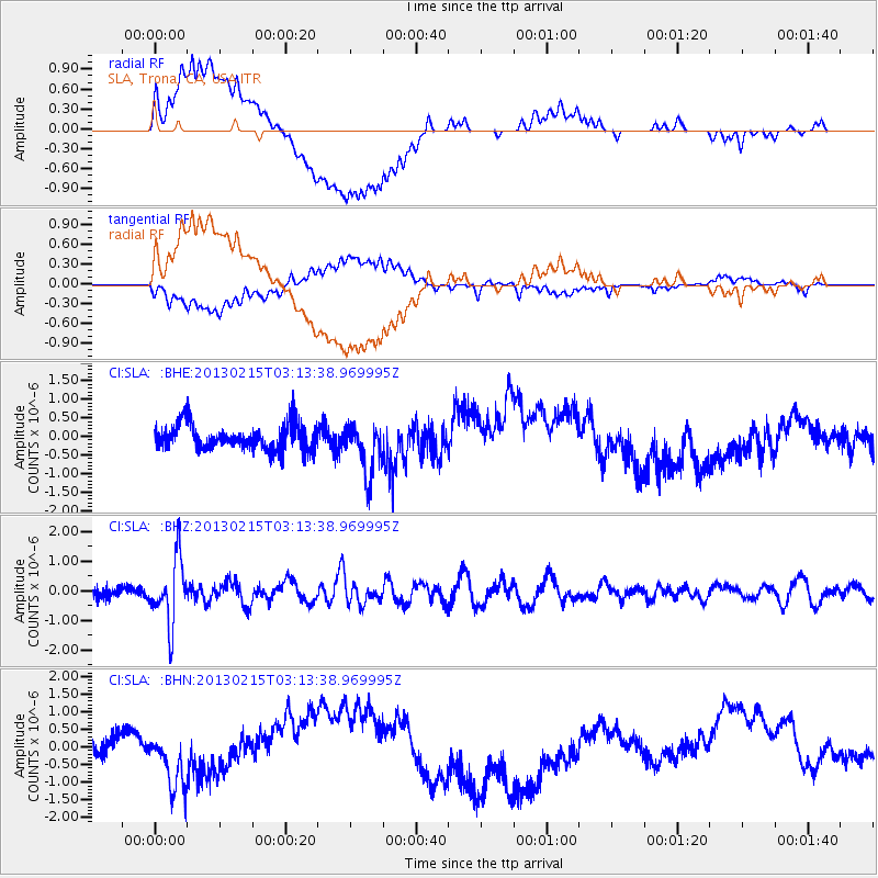
SLA SLA, Trona, CA, USA - Earthquake Result Viewer
*The percent match for this event was below the threshold and hence no stack was calculated.
| Earthquake location: |
Tonga Islands |
| Earthquake latitude/longitude: |
-19.7/-174.5 |
| Earthquake time(UTC): |
2013/02/15 (046) 03:02:23 GMT |
| Earthquake Depth: |
74 km |
| Earthquake Magnitude: |
5.8 MB, 5.7 MW, 5.8 MW |
| Earthquake Catalog/Contributor: |
WHDF/NEIC |
|
| Network: |
CI Caltech Regional Seismic Network |
| Station: |
SLA SLA, Trona, CA, USA |
| Lat/Lon: |
35.89 N/117.28 W |
| Elevation: |
1174 m |
|
| Distance: |
77.4 deg |
| Az: |
44.373 deg |
| Baz: |
234.222 deg |
| Ray Param: |
$rayparam |
*The percent match for this event was below the threshold and hence was not used in the summary stack. |
|
| Radial Match: |
48.233917 % |
| Radial Bump: |
400 |
| Transverse Match: |
50.56374 % |
| Transverse Bump: |
400 |
| SOD ConfigId: |
494114 |
| Insert Time: |
2013-05-04 06:34:18.302 +0000 |
| GWidth: |
2.5 |
| Max Bumps: |
400 |
| Tol: |
0.001 |
|
Signal To Noise
| Channel | StoN | STA | LTA |
| CI:SLA: :BHZ:20130215T03:13:38.969995Z | 4.889816 | 1.0588012E-6 | 2.165319E-7 |
| CI:SLA: :BHN:20130215T03:13:38.969995Z | 1.9521451 | 7.3785094E-7 | 3.7796931E-7 |
| CI:SLA: :BHE:20130215T03:13:38.969995Z | 1.9987342 | 7.008236E-7 | 3.5063368E-7 |
| Arrivals |
| Ps | |
| PpPs | |
| PsPs/PpSs | |


