You are here: Home > Network List > CI - Caltech Regional Seismic Network Stations List
> Station LGU LGU, Camarillo, CA, USA > Earthquake Result Viewer
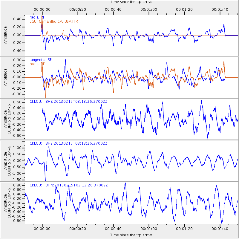
LGU LGU, Camarillo, CA, USA - Earthquake Result Viewer
*The percent match for this event was below the threshold and hence no stack was calculated.
| Earthquake location: |
Tonga Islands |
| Earthquake latitude/longitude: |
-19.7/-174.5 |
| Earthquake time(UTC): |
2013/02/15 (046) 03:02:23 GMT |
| Earthquake Depth: |
74 km |
| Earthquake Magnitude: |
5.8 MB, 5.7 MW, 5.8 MW |
| Earthquake Catalog/Contributor: |
WHDF/NEIC |
|
| Network: |
CI Caltech Regional Seismic Network |
| Station: |
LGU LGU, Camarillo, CA, USA |
| Lat/Lon: |
34.11 N/119.07 W |
| Elevation: |
416 m |
|
| Distance: |
75.1 deg |
| Az: |
44.96 deg |
| Baz: |
233.344 deg |
| Ray Param: |
$rayparam |
*The percent match for this event was below the threshold and hence was not used in the summary stack. |
|
| Radial Match: |
66.69541 % |
| Radial Bump: |
400 |
| Transverse Match: |
56.90154 % |
| Transverse Bump: |
400 |
| SOD ConfigId: |
494114 |
| Insert Time: |
2013-05-04 06:34:23.503 +0000 |
| GWidth: |
2.5 |
| Max Bumps: |
400 |
| Tol: |
0.001 |
|
Signal To Noise
| Channel | StoN | STA | LTA |
| CI:LGU: :BHZ:20130215T03:13:26.37002Z | 3.0041013 | 7.23281E-7 | 2.407645E-7 |
| CI:LGU: :BHN:20130215T03:13:26.37002Z | 0.61835825 | 1.4245771E-7 | 2.3038054E-7 |
| CI:LGU: :BHE:20130215T03:13:26.37002Z | 1.6337028 | 2.7986897E-7 | 1.713096E-7 |
| Arrivals |
| Ps | |
| PpPs | |
| PsPs/PpSs | |


