You are here: Home > Network List > CI - Caltech Regional Seismic Network Stations List
> Station SMM Simmler, CA, USA > Earthquake Result Viewer
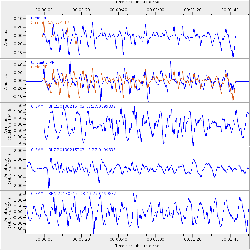
SMM Simmler, CA, USA - Earthquake Result Viewer
*The percent match for this event was below the threshold and hence no stack was calculated.
| Earthquake location: |
Tonga Islands |
| Earthquake latitude/longitude: |
-19.7/-174.5 |
| Earthquake time(UTC): |
2013/02/15 (046) 03:02:23 GMT |
| Earthquake Depth: |
74 km |
| Earthquake Magnitude: |
5.8 MB, 5.7 MW, 5.8 MW |
| Earthquake Catalog/Contributor: |
WHDF/NEIC |
|
| Network: |
CI Caltech Regional Seismic Network |
| Station: |
SMM Simmler, CA, USA |
| Lat/Lon: |
35.31 N/120.00 W |
| Elevation: |
599 m |
|
| Distance: |
75.3 deg |
| Az: |
43.489 deg |
| Baz: |
232.441 deg |
| Ray Param: |
$rayparam |
*The percent match for this event was below the threshold and hence was not used in the summary stack. |
|
| Radial Match: |
65.45216 % |
| Radial Bump: |
400 |
| Transverse Match: |
70.46992 % |
| Transverse Bump: |
400 |
| SOD ConfigId: |
494114 |
| Insert Time: |
2013-05-04 06:34:36.915 +0000 |
| GWidth: |
2.5 |
| Max Bumps: |
400 |
| Tol: |
0.001 |
|
Signal To Noise
| Channel | StoN | STA | LTA |
| CI:SMM: :BHZ:20130215T03:13:27.019983Z | 2.633721 | 8.4845414E-7 | 3.2215033E-7 |
| CI:SMM: :BHN:20130215T03:13:27.019983Z | 1.4455675 | 5.6406776E-7 | 3.9020506E-7 |
| CI:SMM: :BHE:20130215T03:13:27.019983Z | 0.44950995 | 3.5586666E-7 | 7.9167694E-7 |
| Arrivals |
| Ps | |
| PpPs | |
| PsPs/PpSs | |


