You are here: Home > Network List > GT - Global Telemetered Seismograph Network (USAF/USGS) Stations List
> Station CPUP Villa Florida, Paraguay > Earthquake Result Viewer
CPUP Villa Florida, Paraguay - Earthquake Result Viewer
| Earthquake location: |
North Of Honduras |
| Earthquake latitude/longitude: |
16.7/-86.2 |
| Earthquake time(UTC): |
2009/05/28 (148) 08:24:45 GMT |
| Earthquake Depth: |
10 km |
| Earthquake Magnitude: |
6.7 MB, 7.2 MS, 7.3 MW, 7.3 MW |
| Earthquake Catalog/Contributor: |
WHDF/NEIC |
|
| Network: |
GT Global Telemetered Seismograph Network (USAF/USGS) |
| Station: |
CPUP Villa Florida, Paraguay |
| Lat/Lon: |
26.33 S/57.33 W |
| Elevation: |
105 m |
|
| Distance: |
51.2 deg |
| Az: |
146.178 deg |
| Baz: |
323.535 deg |
| Ray Param: |
0.067567974 |
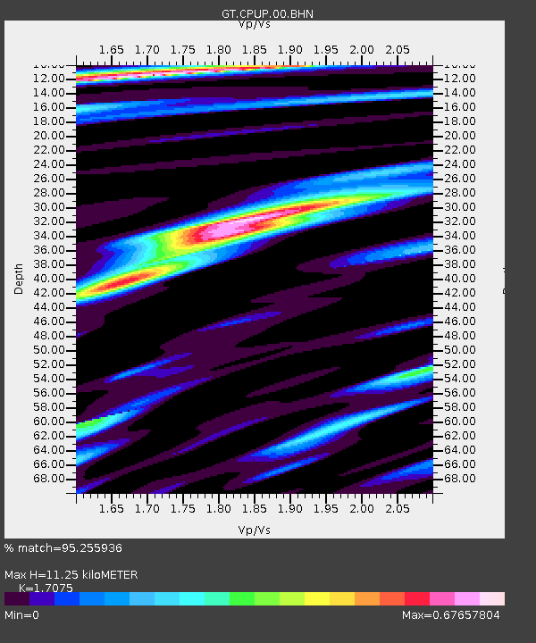
| Estimated Moho Depth: |
11.25 km |
| Estimated Crust Vp/Vs: |
1.71 |
| Assumed Crust Vp: |
6.498 km/s |
| Estimated Crust Vs: |
3.805 km/s |
| Estimated Crust Poisson's Ratio: |
0.24 |
|
| Radial Match: |
95.255936 % |
| Radial Bump: |
266 |
| Transverse Match: |
71.09889 % |
| Transverse Bump: |
400 |
| SOD ConfigId: |
2648 |
| Insert Time: |
2010-02-27 01:50:04.235 +0000 |
| GWidth: |
2.5 |
| Max Bumps: |
400 |
| Tol: |
0.001 |
|
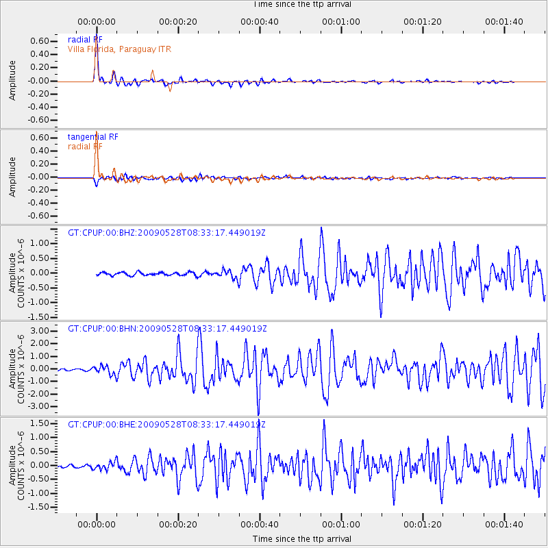
Signal To Noise
| Channel | StoN | STA | LTA |
| GT:CPUP:00:BHN:20090528T08:33:17.449019Z | 6.6548386 | 3.4137227E-7 | 5.1296855E-8 |
| GT:CPUP:00:BHE:20090528T08:33:17.449019Z | 2.7005403 | 1.3588105E-7 | 5.031625E-8 |
| GT:CPUP:00:BHZ:20090528T08:33:17.449019Z | 2.7921157 | 1.4887556E-7 | 5.3319983E-8 |
| Arrivals |
| Ps | 1.3 SECOND |
| PpPs | 4.4 SECOND |
| PsPs/PpSs | 5.7 SECOND |


