You are here: Home > Network List > TA - USArray Transportable Network (new EarthScope stations) Stations List
> Station K22A Casper, WY, USA > Earthquake Result Viewer
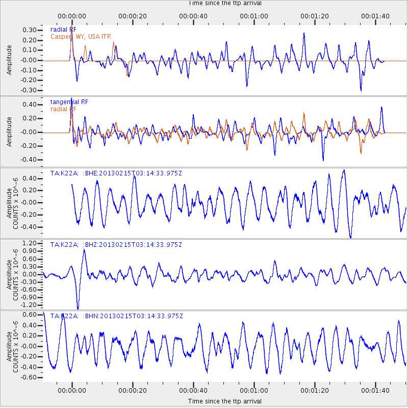
K22A Casper, WY, USA - Earthquake Result Viewer
*The percent match for this event was below the threshold and hence no stack was calculated.
| Earthquake location: |
Tonga Islands |
| Earthquake latitude/longitude: |
-19.7/-174.5 |
| Earthquake time(UTC): |
2013/02/15 (046) 03:02:23 GMT |
| Earthquake Depth: |
74 km |
| Earthquake Magnitude: |
5.8 MB, 5.7 MW, 5.8 MW |
| Earthquake Catalog/Contributor: |
WHDF/NEIC |
|
| Network: |
TA USArray Transportable Network (new EarthScope stations) |
| Station: |
K22A Casper, WY, USA |
| Lat/Lon: |
42.65 N/106.52 W |
| Elevation: |
1686 m |
|
| Distance: |
88.0 deg |
| Az: |
43.17 deg |
| Baz: |
240.876 deg |
| Ray Param: |
$rayparam |
*The percent match for this event was below the threshold and hence was not used in the summary stack. |
|
| Radial Match: |
60.85936 % |
| Radial Bump: |
364 |
| Transverse Match: |
64.43634 % |
| Transverse Bump: |
400 |
| SOD ConfigId: |
494114 |
| Insert Time: |
2013-05-04 06:40:12.809 +0000 |
| GWidth: |
2.5 |
| Max Bumps: |
400 |
| Tol: |
0.001 |
|
Signal To Noise
| Channel | StoN | STA | LTA |
| TA:K22A: :BHZ:20130215T03:14:33.975Z | 5.04488 | 6.3301815E-7 | 1.2547734E-7 |
| TA:K22A: :BHN:20130215T03:14:33.975Z | 0.9217239 | 2.305839E-7 | 2.501659E-7 |
| TA:K22A: :BHE:20130215T03:14:33.975Z | 0.9291821 | 1.954918E-7 | 2.1039126E-7 |
| Arrivals |
| Ps | |
| PpPs | |
| PsPs/PpSs | |


