You are here: Home > Network List > TA - USArray Transportable Network (new EarthScope stations) Stations List
> Station X46A Booneville, MS, USA > Earthquake Result Viewer
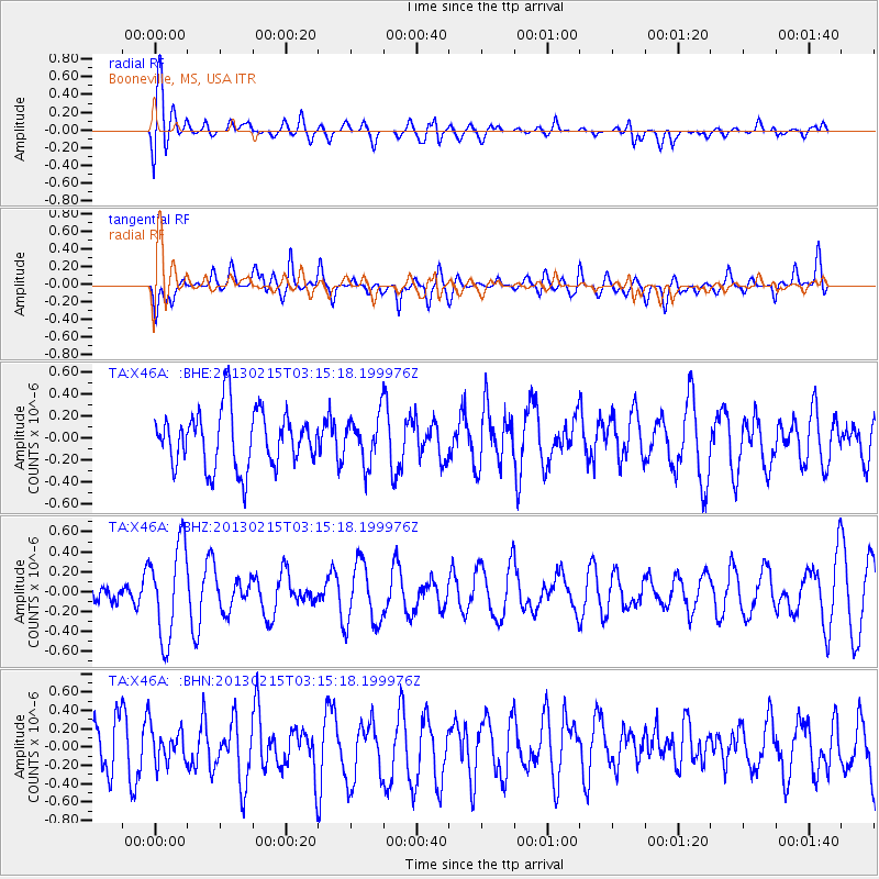
X46A Booneville, MS, USA - Earthquake Result Viewer
*The percent match for this event was below the threshold and hence no stack was calculated.
| Earthquake location: |
Tonga Islands |
| Earthquake latitude/longitude: |
-19.7/-174.5 |
| Earthquake time(UTC): |
2013/02/15 (046) 03:02:23 GMT |
| Earthquake Depth: |
74 km |
| Earthquake Magnitude: |
5.8 MB, 5.7 MW, 5.8 MW |
| Earthquake Catalog/Contributor: |
WHDF/NEIC |
|
| Network: |
TA USArray Transportable Network (new EarthScope stations) |
| Station: |
X46A Booneville, MS, USA |
| Lat/Lon: |
34.56 N/88.58 W |
| Elevation: |
150 m |
|
| Distance: |
97.7 deg |
| Az: |
56.167 deg |
| Baz: |
251.455 deg |
| Ray Param: |
$rayparam |
*The percent match for this event was below the threshold and hence was not used in the summary stack. |
|
| Radial Match: |
67.10042 % |
| Radial Bump: |
400 |
| Transverse Match: |
48.57419 % |
| Transverse Bump: |
400 |
| SOD ConfigId: |
494114 |
| Insert Time: |
2013-05-04 06:42:57.918 +0000 |
| GWidth: |
2.5 |
| Max Bumps: |
400 |
| Tol: |
0.001 |
|
Signal To Noise
| Channel | StoN | STA | LTA |
| TA:X46A: :BHZ:20130215T03:15:18.199976Z | 2.0874357 | 4.6493201E-7 | 2.2272877E-7 |
| TA:X46A: :BHN:20130215T03:15:18.199976Z | 0.6093348 | 1.8769407E-7 | 3.080311E-7 |
| TA:X46A: :BHE:20130215T03:15:18.199976Z | 0.82279664 | 2.0994472E-7 | 2.551599E-7 |
| Arrivals |
| Ps | |
| PpPs | |
| PsPs/PpSs | |


