You are here: Home > Network List > UW - Pacific Northwest Regional Seismic Network Stations List
> Station OMAK Colville Reservation, Omak, WA, USA > Earthquake Result Viewer
OMAK Colville Reservation, Omak, WA, USA - Earthquake Result Viewer
*The percent match for this event was below the threshold and hence no stack was calculated.
| Earthquake location: |
Tonga Islands |
| Earthquake latitude/longitude: |
-19.7/-174.5 |
| Earthquake time(UTC): |
2013/02/15 (046) 03:02:23 GMT |
| Earthquake Depth: |
74 km |
| Earthquake Magnitude: |
5.8 MB, 5.7 MW, 5.8 MW |
| Earthquake Catalog/Contributor: |
WHDF/NEIC |
|
| Network: |
UW Pacific Northwest Regional Seismic Network |
| Station: |
OMAK Colville Reservation, Omak, WA, USA |
| Lat/Lon: |
48.36 N/119.33 W |
| Elevation: |
696 m |
|
| Distance: |
83.7 deg |
| Az: |
33.402 deg |
| Baz: |
231.035 deg |
| Ray Param: |
$rayparam |
*The percent match for this event was below the threshold and hence was not used in the summary stack. |
|
| Radial Match: |
52.37164 % |
| Radial Bump: |
367 |
| Transverse Match: |
57.294846 % |
| Transverse Bump: |
400 |
| SOD ConfigId: |
494114 |
| Insert Time: |
2013-05-04 06:44:05.369 +0000 |
| GWidth: |
2.5 |
| Max Bumps: |
400 |
| Tol: |
0.001 |
|
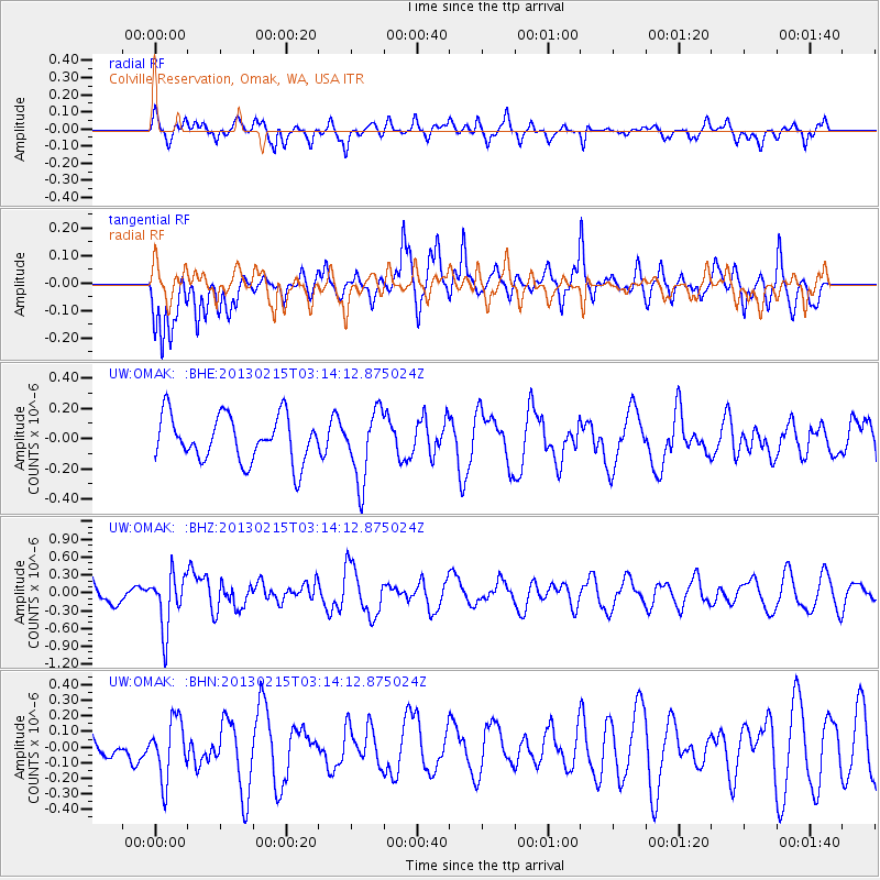
Signal To Noise
| Channel | StoN | STA | LTA |
| UW:OMAK: :BHZ:20130215T03:14:12.875024Z | 2.3157625 | 4.6043232E-7 | 1.9882535E-7 |
| UW:OMAK: :BHN:20130215T03:14:12.875024Z | 1.2697316 | 1.8865799E-7 | 1.4858101E-7 |
| UW:OMAK: :BHE:20130215T03:14:12.875024Z | 1.5323045 | 2.3224288E-7 | 1.5156444E-7 |
| Arrivals |
| Ps | |
| PpPs | |
| PsPs/PpSs | |


