You are here: Home > Network List > UW - Pacific Northwest Regional Seismic Network Stations List
> Station UMAT Pilot Rock, OR, USA > Earthquake Result Viewer
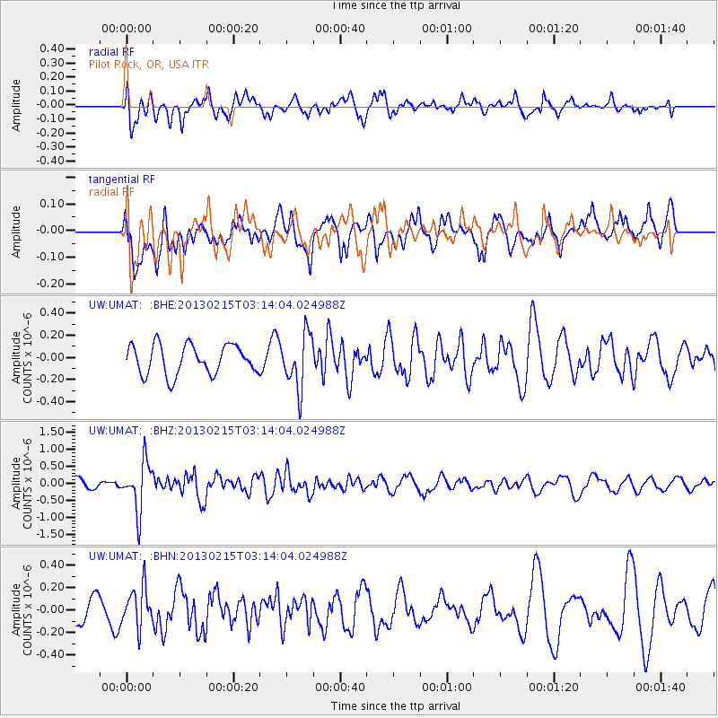
UMAT Pilot Rock, OR, USA - Earthquake Result Viewer
*The percent match for this event was below the threshold and hence no stack was calculated.
| Earthquake location: |
Tonga Islands |
| Earthquake latitude/longitude: |
-19.7/-174.5 |
| Earthquake time(UTC): |
2013/02/15 (046) 03:02:23 GMT |
| Earthquake Depth: |
74 km |
| Earthquake Magnitude: |
5.8 MB, 5.7 MW, 5.8 MW |
| Earthquake Catalog/Contributor: |
WHDF/NEIC |
|
| Network: |
UW Pacific Northwest Regional Seismic Network |
| Station: |
UMAT Pilot Rock, OR, USA |
| Lat/Lon: |
45.29 N/118.96 W |
| Elevation: |
1318 m |
|
| Distance: |
82.0 deg |
| Az: |
35.978 deg |
| Baz: |
231.626 deg |
| Ray Param: |
$rayparam |
*The percent match for this event was below the threshold and hence was not used in the summary stack. |
|
| Radial Match: |
56.60241 % |
| Radial Bump: |
400 |
| Transverse Match: |
34.95254 % |
| Transverse Bump: |
400 |
| SOD ConfigId: |
494114 |
| Insert Time: |
2013-05-04 06:44:22.174 +0000 |
| GWidth: |
2.5 |
| Max Bumps: |
400 |
| Tol: |
0.001 |
|
Signal To Noise
| Channel | StoN | STA | LTA |
| UW:UMAT: :BHZ:20130215T03:14:04.024988Z | 3.7434905 | 7.316135E-7 | 1.9543619E-7 |
| UW:UMAT: :BHN:20130215T03:14:04.024988Z | 1.3197633 | 1.7587256E-7 | 1.3326067E-7 |
| UW:UMAT: :BHE:20130215T03:14:04.024988Z | 1.8468882 | 2.4478572E-7 | 1.3253955E-7 |
| Arrivals |
| Ps | |
| PpPs | |
| PsPs/PpSs | |


