You are here: Home > Network List > G - GEOSCOPE Stations List
> Station FOMA Nahampoana reservation, Fort Dauphin, Madagascar > Earthquake Result Viewer
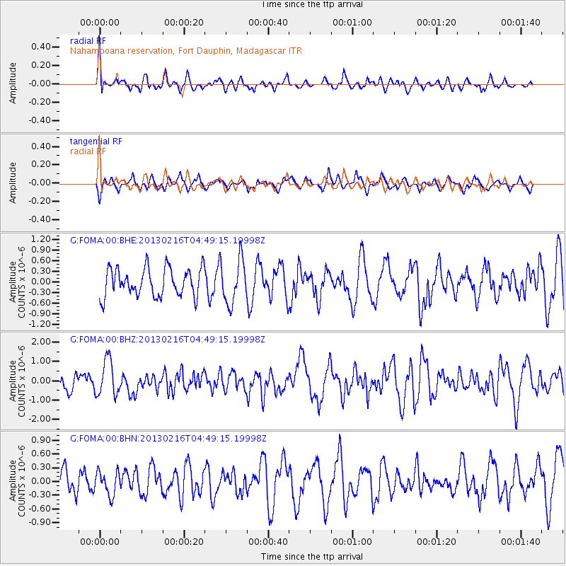
FOMA Nahampoana reservation, Fort Dauphin, Madagascar - Earthquake Result Viewer
*The percent match for this event was below the threshold and hence no stack was calculated.
| Earthquake location: |
Mindanao, Philippines |
| Earthquake latitude/longitude: |
5.8/125.7 |
| Earthquake time(UTC): |
2013/02/16 (047) 04:37:36 GMT |
| Earthquake Depth: |
105 km |
| Earthquake Magnitude: |
5.9 MB, 6.1 MW, 6.2 MW |
| Earthquake Catalog/Contributor: |
WHDF/NEIC |
|
| Network: |
G GEOSCOPE |
| Station: |
FOMA Nahampoana reservation, Fort Dauphin, Madagascar |
| Lat/Lon: |
24.98 S/46.98 E |
| Elevation: |
26 m |
|
| Distance: |
82.3 deg |
| Az: |
243.928 deg |
| Baz: |
79.966 deg |
| Ray Param: |
$rayparam |
*The percent match for this event was below the threshold and hence was not used in the summary stack. |
|
| Radial Match: |
48.624207 % |
| Radial Bump: |
400 |
| Transverse Match: |
55.571167 % |
| Transverse Bump: |
400 |
| SOD ConfigId: |
494114 |
| Insert Time: |
2013-05-04 06:49:04.883 +0000 |
| GWidth: |
2.5 |
| Max Bumps: |
400 |
| Tol: |
0.001 |
|
Signal To Noise
| Channel | StoN | STA | LTA |
| G:FOMA:00:BHZ:20130216T04:49:15.19998Z | 2.2219262 | 9.3843016E-7 | 4.2234984E-7 |
| G:FOMA:00:BHN:20130216T04:49:15.19998Z | 0.64229125 | 2.6657304E-7 | 4.1503455E-7 |
| G:FOMA:00:BHE:20130216T04:49:15.19998Z | 1.5653292 | 6.1601304E-7 | 3.9353574E-7 |
| Arrivals |
| Ps | |
| PpPs | |
| PsPs/PpSs | |


