You are here: Home > Network List > CI - Caltech Regional Seismic Network Stations List
> Station SMM Simmler, CA, USA > Earthquake Result Viewer
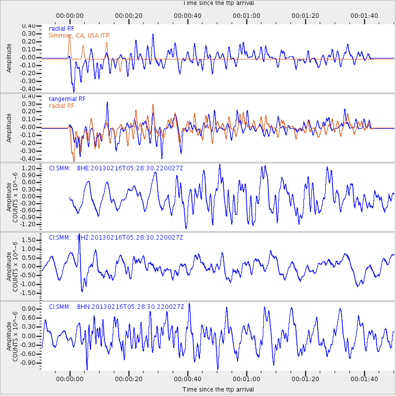
SMM Simmler, CA, USA - Earthquake Result Viewer
*The percent match for this event was below the threshold and hence no stack was calculated.
| Earthquake location: |
Off E. Coast Of N. Island, N.Z. |
| Earthquake latitude/longitude: |
-36.5/177.9 |
| Earthquake time(UTC): |
2013/02/16 (047) 05:16:17 GMT |
| Earthquake Depth: |
207 km |
| Earthquake Magnitude: |
5.7 MB, 5.8 MW, 5.8 MW |
| Earthquake Catalog/Contributor: |
WHDF/NEIC |
|
| Network: |
CI Caltech Regional Seismic Network |
| Station: |
SMM Simmler, CA, USA |
| Lat/Lon: |
35.31 N/120.00 W |
| Elevation: |
599 m |
|
| Distance: |
91.9 deg |
| Az: |
46.298 deg |
| Baz: |
225.411 deg |
| Ray Param: |
$rayparam |
*The percent match for this event was below the threshold and hence was not used in the summary stack. |
|
| Radial Match: |
64.81947 % |
| Radial Bump: |
400 |
| Transverse Match: |
78.765274 % |
| Transverse Bump: |
400 |
| SOD ConfigId: |
494114 |
| Insert Time: |
2013-05-04 06:54:55.724 +0000 |
| GWidth: |
2.5 |
| Max Bumps: |
400 |
| Tol: |
0.001 |
|
Signal To Noise
| Channel | StoN | STA | LTA |
| CI:SMM: :BHZ:20130216T05:28:30.220027Z | 2.4354756 | 8.523263E-7 | 3.49963E-7 |
| CI:SMM: :BHN:20130216T05:28:30.220027Z | 0.9113393 | 2.3321469E-7 | 2.5590325E-7 |
| CI:SMM: :BHE:20130216T05:28:30.220027Z | 1.305744 | 4.9925103E-7 | 3.8234984E-7 |
| Arrivals |
| Ps | |
| PpPs | |
| PsPs/PpSs | |


