You are here: Home > Network List > GT - Global Telemetered Seismograph Network (USAF/USGS) Stations List
> Station CPUP Villa Florida, Paraguay > Earthquake Result Viewer
CPUP Villa Florida, Paraguay - Earthquake Result Viewer
| Earthquake location: |
Galapagos Islands Region |
| Earthquake latitude/longitude: |
1.1/-90.5 |
| Earthquake time(UTC): |
2006/02/04 (035) 09:17:04 GMT |
| Earthquake Depth: |
10 km |
| Earthquake Magnitude: |
5.4 MB, 5.4 MS, 5.9 MW, 5.9 MW |
| Earthquake Catalog/Contributor: |
WHDF/NEIC |
|
| Network: |
GT Global Telemetered Seismograph Network (USAF/USGS) |
| Station: |
CPUP Villa Florida, Paraguay |
| Lat/Lon: |
26.33 S/57.33 W |
| Elevation: |
105 m |
|
| Distance: |
42.0 deg |
| Az: |
132.872 deg |
| Baz: |
305.264 deg |
| Ray Param: |
0.07342912 |
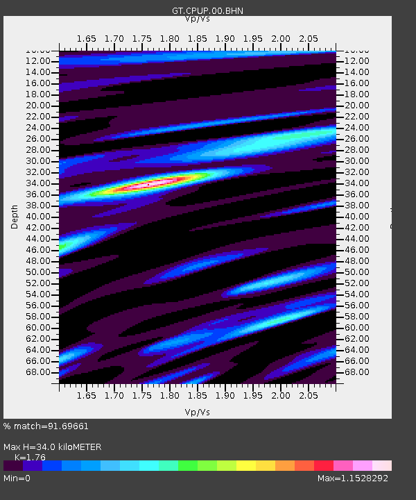
| Estimated Moho Depth: |
34.0 km |
| Estimated Crust Vp/Vs: |
1.76 |
| Assumed Crust Vp: |
6.498 km/s |
| Estimated Crust Vs: |
3.692 km/s |
| Estimated Crust Poisson's Ratio: |
0.26 |
|
| Radial Match: |
91.69661 % |
| Radial Bump: |
351 |
| Transverse Match: |
64.01521 % |
| Transverse Bump: |
400 |
| SOD ConfigId: |
4977 |
| Insert Time: |
2010-02-27 01:50:34.475 +0000 |
| GWidth: |
2.5 |
| Max Bumps: |
400 |
| Tol: |
0.001 |
|

Signal To Noise
| Channel | StoN | STA | LTA |
| GT:CPUP:00:BHN:20060204T09:24:24.574009Z | 2.1250038 | 8.017138E-8 | 3.772764E-8 |
| GT:CPUP:00:BHE:20060204T09:24:24.574009Z | 2.8785582 | 1.464583E-7 | 5.0879052E-8 |
| GT:CPUP:00:BHZ:20060204T09:24:24.574009Z | 2.4939504 | 2.310673E-7 | 9.265112E-8 |
| Arrivals |
| Ps | 4.3 SECOND |
| PpPs | 13 SECOND |
| PsPs/PpSs | 18 SECOND |


