You are here: Home > Network List > CI - Caltech Regional Seismic Network Stations List
> Station SWS Sam W. Stewart, Westmorland, CA, USA > Earthquake Result Viewer
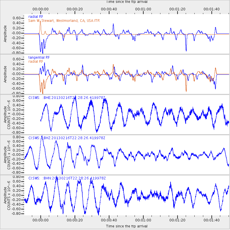
SWS Sam W. Stewart, Westmorland, CA, USA - Earthquake Result Viewer
*The percent match for this event was below the threshold and hence no stack was calculated.
| Earthquake location: |
Kuril Islands |
| Earthquake latitude/longitude: |
43.5/146.7 |
| Earthquake time(UTC): |
2013/02/16 (047) 22:17:32 GMT |
| Earthquake Depth: |
46 km |
| Earthquake Magnitude: |
5.6 MB, 5.1 MS, 5.3 MW, 5.4 MW |
| Earthquake Catalog/Contributor: |
WHDF/NEIC |
|
| Network: |
CI Caltech Regional Seismic Network |
| Station: |
SWS Sam W. Stewart, Westmorland, CA, USA |
| Lat/Lon: |
32.94 N/115.80 W |
| Elevation: |
140 m |
|
| Distance: |
73.1 deg |
| Az: |
60.628 deg |
| Baz: |
311.093 deg |
| Ray Param: |
$rayparam |
*The percent match for this event was below the threshold and hence was not used in the summary stack. |
|
| Radial Match: |
80.62771 % |
| Radial Bump: |
400 |
| Transverse Match: |
76.9979 % |
| Transverse Bump: |
395 |
| SOD ConfigId: |
494114 |
| Insert Time: |
2013-05-04 06:59:57.098 +0000 |
| GWidth: |
2.5 |
| Max Bumps: |
400 |
| Tol: |
0.001 |
|
Signal To Noise
| Channel | StoN | STA | LTA |
| CI:SWS: :BHZ:20130216T22:28:26.419978Z | 2.9733229 | 4.754696E-7 | 1.5991186E-7 |
| CI:SWS: :BHN:20130216T22:28:26.419978Z | 0.88418067 | 2.9808808E-7 | 3.3713482E-7 |
| CI:SWS: :BHE:20130216T22:28:26.419978Z | 1.3379362 | 5.0770194E-7 | 3.7946648E-7 |
| Arrivals |
| Ps | |
| PpPs | |
| PsPs/PpSs | |


