You are here: Home > Network List > TA - USArray Transportable Network (new EarthScope stations) Stations List
> Station X49A Woodville, AR, USA > Earthquake Result Viewer
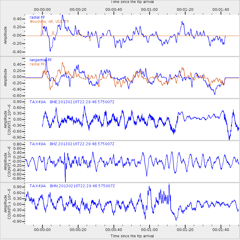
X49A Woodville, AR, USA - Earthquake Result Viewer
*The percent match for this event was below the threshold and hence no stack was calculated.
| Earthquake location: |
Kuril Islands |
| Earthquake latitude/longitude: |
43.5/146.7 |
| Earthquake time(UTC): |
2013/02/16 (047) 22:17:32 GMT |
| Earthquake Depth: |
46 km |
| Earthquake Magnitude: |
5.6 MB, 5.1 MS, 5.3 MW, 5.4 MW |
| Earthquake Catalog/Contributor: |
WHDF/NEIC |
|
| Network: |
TA USArray Transportable Network (new EarthScope stations) |
| Station: |
X49A Woodville, AR, USA |
| Lat/Lon: |
34.51 N/86.33 W |
| Elevation: |
182 m |
|
| Distance: |
88.5 deg |
| Az: |
41.278 deg |
| Baz: |
324.481 deg |
| Ray Param: |
$rayparam |
*The percent match for this event was below the threshold and hence was not used in the summary stack. |
|
| Radial Match: |
34.46623 % |
| Radial Bump: |
400 |
| Transverse Match: |
36.44802 % |
| Transverse Bump: |
400 |
| SOD ConfigId: |
494114 |
| Insert Time: |
2013-05-04 07:08:17.359 +0000 |
| GWidth: |
2.5 |
| Max Bumps: |
400 |
| Tol: |
0.001 |
|
Signal To Noise
| Channel | StoN | STA | LTA |
| TA:X49A: :BHZ:20130216T22:29:48.575007Z | 1.0132222 | 1.8331276E-7 | 1.809206E-7 |
| TA:X49A: :BHN:20130216T22:29:48.575007Z | 1.4358033 | 4.8339456E-7 | 3.3667186E-7 |
| TA:X49A: :BHE:20130216T22:29:48.575007Z | 0.8104857 | 1.777432E-7 | 2.1930455E-7 |
| Arrivals |
| Ps | |
| PpPs | |
| PsPs/PpSs | |


