You are here: Home > Network List > TO - Tectonic Observatory Stations List
> Station CC33 CCSE CC33 > Earthquake Result Viewer
CC33 CCSE CC33 - Earthquake Result Viewer
| Earthquake location: |
Kermadec Islands Region |
| Earthquake latitude/longitude: |
-30.5/-176.5 |
| Earthquake time(UTC): |
2014/07/03 (184) 19:50:05 GMT |
| Earthquake Depth: |
20 km |
| Earthquake Magnitude: |
6.3 MWB, 6.6 MI |
| Earthquake Catalog/Contributor: |
NEIC PDE/NEIC COMCAT |
|
| Network: |
TO Tectonic Observatory |
| Station: |
CC33 CCSE CC33 |
| Lat/Lon: |
36.34 N/119.12 W |
| Elevation: |
126 m |
|
| Distance: |
85.6 deg |
| Az: |
43.017 deg |
| Baz: |
226.809 deg |
| Ray Param: |
0.044642758 |
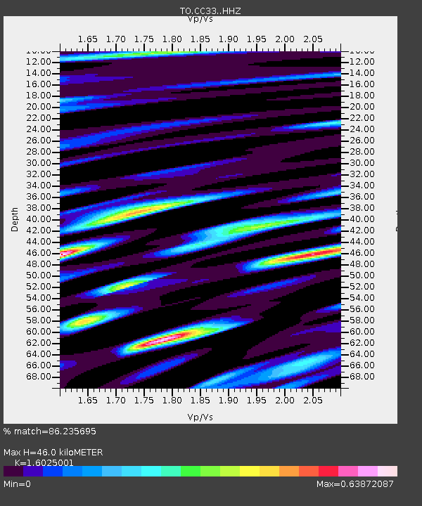
| Estimated Moho Depth: |
46.0 km |
| Estimated Crust Vp/Vs: |
1.60 |
| Assumed Crust Vp: |
6.291 km/s |
| Estimated Crust Vs: |
3.926 km/s |
| Estimated Crust Poisson's Ratio: |
0.18 |
|
| Radial Match: |
86.235695 % |
| Radial Bump: |
381 |
| Transverse Match: |
80.4794 % |
| Transverse Bump: |
365 |
| SOD ConfigId: |
3390531 |
| Insert Time: |
2019-04-12 16:25:23.072 +0000 |
| GWidth: |
2.5 |
| Max Bumps: |
400 |
| Tol: |
0.001 |
|

Signal To Noise
| Channel | StoN | STA | LTA |
| TO:CC33: :HHZ:20140703T20:02:10.320029Z | 32.589737 | 3.5840826E-6 | 1.0997581E-7 |
| TO:CC33: :HHN:20140703T20:02:10.320029Z | 4.5384607 | 6.122037E-7 | 1.3489236E-7 |
| TO:CC33: :HHE:20140703T20:02:10.320029Z | 9.892742 | 1.1584475E-6 | 1.1710074E-7 |
| Arrivals |
| Ps | 4.5 SECOND |
| PpPs | 19 SECOND |
| PsPs/PpSs | 23 SECOND |


