You are here: Home > Network List > XD14 - Illuminating the architecture of the greater Mount St. Helens magmatic systems f Stations List
> Station MG05 "Mount St Helens, WA" > Earthquake Result Viewer
MG05 "Mount St Helens, WA" - Earthquake Result Viewer
| Earthquake location: |
Kermadec Islands Region |
| Earthquake latitude/longitude: |
-30.5/-176.5 |
| Earthquake time(UTC): |
2014/07/03 (184) 19:50:05 GMT |
| Earthquake Depth: |
20 km |
| Earthquake Magnitude: |
6.3 MWB, 6.6 MI |
| Earthquake Catalog/Contributor: |
NEIC PDE/NEIC COMCAT |
|
| Network: |
XD Illuminating the architecture of the greater Mount St. Helens magmatic systems f |
| Station: |
MG05 "Mount St Helens, WA" |
| Lat/Lon: |
46.31 N/122.34 W |
| Elevation: |
1283 m |
|
| Distance: |
90.8 deg |
| Az: |
34.208 deg |
| Baz: |
224.406 deg |
| Ray Param: |
0.041644566 |
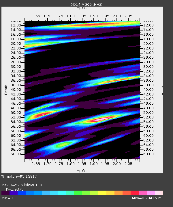
| Estimated Moho Depth: |
52.5 km |
| Estimated Crust Vp/Vs: |
1.94 |
| Assumed Crust Vp: |
6.566 km/s |
| Estimated Crust Vs: |
3.389 km/s |
| Estimated Crust Poisson's Ratio: |
0.32 |
|
| Radial Match: |
95.15817 % |
| Radial Bump: |
248 |
| Transverse Match: |
86.973724 % |
| Transverse Bump: |
353 |
| SOD ConfigId: |
3390531 |
| Insert Time: |
2019-04-12 16:26:09.595 +0000 |
| GWidth: |
2.5 |
| Max Bumps: |
400 |
| Tol: |
0.001 |
|

Signal To Noise
| Channel | StoN | STA | LTA |
| XD:MG05: :HHZ:20140703T20:02:35.255027Z | 55.725235 | 3.8776216E-6 | 6.958466E-8 |
| XD:MG05: :HHN:20140703T20:02:35.255027Z | 16.157253 | 1.2452722E-6 | 7.707202E-8 |
| XD:MG05: :HHE:20140703T20:02:35.255027Z | 11.930184 | 1.3795412E-6 | 1.1563453E-7 |
| Arrivals |
| Ps | 7.6 SECOND |
| PpPs | 23 SECOND |
| PsPs/PpSs | 31 SECOND |


