You are here: Home > Network List > XD14 - Illuminating the architecture of the greater Mount St. Helens magmatic systems f Stations List
> Station MH01 "Mount St Helens, WA" > Earthquake Result Viewer
MH01 "Mount St Helens, WA" - Earthquake Result Viewer
| Earthquake location: |
Kermadec Islands Region |
| Earthquake latitude/longitude: |
-30.5/-176.5 |
| Earthquake time(UTC): |
2014/07/03 (184) 19:50:05 GMT |
| Earthquake Depth: |
20 km |
| Earthquake Magnitude: |
6.3 MWB, 6.6 MI |
| Earthquake Catalog/Contributor: |
NEIC PDE/NEIC COMCAT |
|
| Network: |
XD Illuminating the architecture of the greater Mount St. Helens magmatic systems f |
| Station: |
MH01 "Mount St Helens, WA" |
| Lat/Lon: |
46.26 N/122.81 W |
| Elevation: |
197 m |
|
| Distance: |
90.6 deg |
| Az: |
34.006 deg |
| Baz: |
224.074 deg |
| Ray Param: |
0.041662734 |
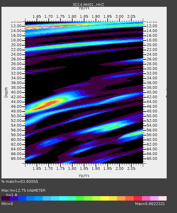
| Estimated Moho Depth: |
12.75 km |
| Estimated Crust Vp/Vs: |
1.60 |
| Assumed Crust Vp: |
6.566 km/s |
| Estimated Crust Vs: |
4.104 km/s |
| Estimated Crust Poisson's Ratio: |
0.18 |
|
| Radial Match: |
83.90855 % |
| Radial Bump: |
400 |
| Transverse Match: |
79.183685 % |
| Transverse Bump: |
400 |
| SOD ConfigId: |
3390531 |
| Insert Time: |
2019-04-12 16:26:10.373 +0000 |
| GWidth: |
2.5 |
| Max Bumps: |
400 |
| Tol: |
0.001 |
|

Signal To Noise
| Channel | StoN | STA | LTA |
| XD:MH01: :HHZ:20140703T20:02:34.074973Z | 39.790928 | 5.4973907E-6 | 1.3815689E-7 |
| XD:MH01: :HHN:20140703T20:02:34.074973Z | 3.328558 | 6.241484E-7 | 1.8751317E-7 |
| XD:MH01: :HHE:20140703T20:02:34.074973Z | 3.3420541 | 4.4449007E-7 | 1.3299906E-7 |
| Arrivals |
| Ps | 1.2 SECOND |
| PpPs | 4.9 SECOND |
| PsPs/PpSs | 6.1 SECOND |


