You are here: Home > Network List > UW - Pacific Northwest Regional Seismic Network Stations List
> Station HOOD Mt Hood Meadows, OR CREST BB SMO > Earthquake Result Viewer
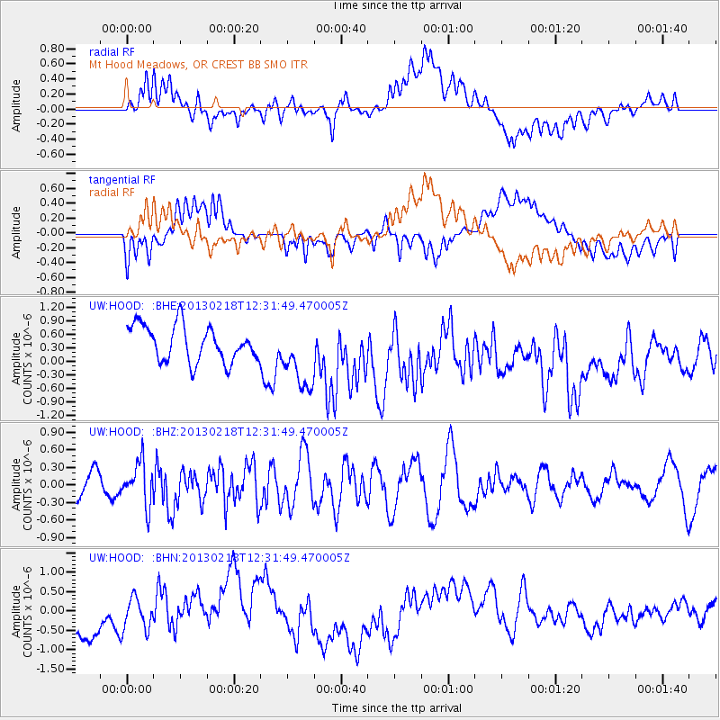
HOOD Mt Hood Meadows, OR CREST BB SMO - Earthquake Result Viewer
*The percent match for this event was below the threshold and hence no stack was calculated.
| Earthquake location: |
Kermadec Islands, New Zealand |
| Earthquake latitude/longitude: |
-30.8/-178.1 |
| Earthquake time(UTC): |
2013/02/18 (049) 12:19:18 GMT |
| Earthquake Depth: |
35 km |
| Earthquake Magnitude: |
5.8 MB, 5.5 MS, 5.9 MW, 5.9 MW |
| Earthquake Catalog/Contributor: |
WHDF/NEIC |
|
| Network: |
UW Pacific Northwest Regional Seismic Network |
| Station: |
HOOD Mt Hood Meadows, OR CREST BB SMO |
| Lat/Lon: |
45.32 N/121.65 W |
| Elevation: |
1520 m |
|
| Distance: |
91.5 deg |
| Az: |
36.036 deg |
| Baz: |
225.865 deg |
| Ray Param: |
$rayparam |
*The percent match for this event was below the threshold and hence was not used in the summary stack. |
|
| Radial Match: |
38.09287 % |
| Radial Bump: |
400 |
| Transverse Match: |
40.626293 % |
| Transverse Bump: |
400 |
| SOD ConfigId: |
494114 |
| Insert Time: |
2013-05-04 07:26:48.938 +0000 |
| GWidth: |
2.5 |
| Max Bumps: |
400 |
| Tol: |
0.001 |
|
Signal To Noise
| Channel | StoN | STA | LTA |
| UW:HOOD: :BHZ:20130218T12:31:49.470005Z | 1.6967925 | 3.6326344E-7 | 2.1408832E-7 |
| UW:HOOD: :BHN:20130218T12:31:49.470005Z | 0.47381505 | 4.8725076E-7 | 1.0283565E-6 |
| UW:HOOD: :BHE:20130218T12:31:49.470005Z | 1.8948793 | 7.5048115E-7 | 3.960575E-7 |
| Arrivals |
| Ps | |
| PpPs | |
| PsPs/PpSs | |


