You are here: Home > Network List > CI - Caltech Regional Seismic Network Stations List
> Station LRL Laurel Mtn Radio Fac, Ridgecrest, CA, USA > Earthquake Result Viewer
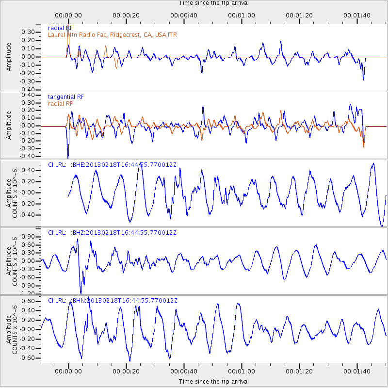
LRL Laurel Mtn Radio Fac, Ridgecrest, CA, USA - Earthquake Result Viewer
*The percent match for this event was below the threshold and hence no stack was calculated.
| Earthquake location: |
Kermadec Islands, New Zealand |
| Earthquake latitude/longitude: |
-30.7/-178.1 |
| Earthquake time(UTC): |
2013/02/18 (049) 16:32:47 GMT |
| Earthquake Depth: |
50 km |
| Earthquake Magnitude: |
5.6 MB, 5.5 MW, 5.5 MW |
| Earthquake Catalog/Contributor: |
WHDF/NEIC |
|
| Network: |
CI Caltech Regional Seismic Network |
| Station: |
LRL Laurel Mtn Radio Fac, Ridgecrest, CA, USA |
| Lat/Lon: |
35.48 N/117.68 W |
| Elevation: |
1340 m |
|
| Distance: |
87.0 deg |
| Az: |
45.324 deg |
| Baz: |
228.601 deg |
| Ray Param: |
$rayparam |
*The percent match for this event was below the threshold and hence was not used in the summary stack. |
|
| Radial Match: |
43.523853 % |
| Radial Bump: |
383 |
| Transverse Match: |
58.88705 % |
| Transverse Bump: |
400 |
| SOD ConfigId: |
494114 |
| Insert Time: |
2013-05-04 07:31:02.149 +0000 |
| GWidth: |
2.5 |
| Max Bumps: |
400 |
| Tol: |
0.001 |
|
Signal To Noise
| Channel | StoN | STA | LTA |
| CI:LRL: :BHZ:20130218T16:44:55.770012Z | 3.5795746 | 5.536424E-7 | 1.546671E-7 |
| CI:LRL: :BHN:20130218T16:44:55.770012Z | 1.6042151 | 3.9865452E-7 | 2.485044E-7 |
| CI:LRL: :BHE:20130218T16:44:55.770012Z | 0.8721321 | 2.219342E-7 | 2.5447315E-7 |
| Arrivals |
| Ps | |
| PpPs | |
| PsPs/PpSs | |


