You are here: Home > Network List > TA - USArray Transportable Network (new EarthScope stations) Stations List
> Station T41A Mountain View, MO, USA > Earthquake Result Viewer
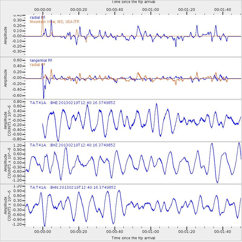
T41A Mountain View, MO, USA - Earthquake Result Viewer
*The percent match for this event was below the threshold and hence no stack was calculated.
| Earthquake location: |
Near East Coast Of Honshu, Japan |
| Earthquake latitude/longitude: |
35.3/141.0 |
| Earthquake time(UTC): |
2013/02/19 (050) 12:27:36 GMT |
| Earthquake Depth: |
20 km |
| Earthquake Magnitude: |
5.5 MB, 5.2 MS, 5.4 MW, 5.3 MW |
| Earthquake Catalog/Contributor: |
WHDF/NEIC |
|
| Network: |
TA USArray Transportable Network (new EarthScope stations) |
| Station: |
T41A Mountain View, MO, USA |
| Lat/Lon: |
37.04 N/91.76 W |
| Elevation: |
366 m |
|
| Distance: |
93.0 deg |
| Az: |
39.605 deg |
| Baz: |
319.3 deg |
| Ray Param: |
$rayparam |
*The percent match for this event was below the threshold and hence was not used in the summary stack. |
|
| Radial Match: |
34.081913 % |
| Radial Bump: |
400 |
| Transverse Match: |
81.879074 % |
| Transverse Bump: |
400 |
| SOD ConfigId: |
494114 |
| Insert Time: |
2013-05-09 04:11:39.333 +0000 |
| GWidth: |
2.5 |
| Max Bumps: |
400 |
| Tol: |
0.001 |
|
Signal To Noise
| Channel | StoN | STA | LTA |
| TA:T41A: :BHZ:20130219T12:40:16.374985Z | 0.8527756 | 4.4817267E-7 | 5.255459E-7 |
| TA:T41A: :BHN:20130219T12:40:16.374985Z | 2.5938907 | 7.313993E-7 | 2.8197E-7 |
| TA:T41A: :BHE:20130219T12:40:16.374985Z | 1.0316079 | 3.7095478E-7 | 3.5958894E-7 |
| Arrivals |
| Ps | |
| PpPs | |
| PsPs/PpSs | |


