You are here: Home > Network List > YT07 - POLENET Stations List
> Station WHIT WHIT > Earthquake Result Viewer
WHIT WHIT - Earthquake Result Viewer
| Earthquake location: |
Kermadec Islands Region |
| Earthquake latitude/longitude: |
-30.5/-176.5 |
| Earthquake time(UTC): |
2014/07/03 (184) 19:50:05 GMT |
| Earthquake Depth: |
20 km |
| Earthquake Magnitude: |
6.3 MWB, 6.6 MI |
| Earthquake Catalog/Contributor: |
NEIC PDE/NEIC COMCAT |
|
| Network: |
YT POLENET |
| Station: |
WHIT WHIT |
| Lat/Lon: |
82.68 S/104.39 W |
| Elevation: |
2343 m |
|
| Distance: |
57.6 deg |
| Az: |
171.693 deg |
| Baz: |
283.531 deg |
| Ray Param: |
0.06334029 |
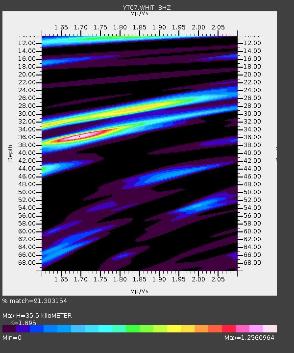
| Estimated Moho Depth: |
35.5 km |
| Estimated Crust Vp/Vs: |
1.70 |
| Assumed Crust Vp: |
6.356 km/s |
| Estimated Crust Vs: |
3.75 km/s |
| Estimated Crust Poisson's Ratio: |
0.23 |
|
| Radial Match: |
91.303154 % |
| Radial Bump: |
376 |
| Transverse Match: |
85.95723 % |
| Transverse Bump: |
400 |
| SOD ConfigId: |
3390531 |
| Insert Time: |
2019-04-12 16:27:05.111 +0000 |
| GWidth: |
2.5 |
| Max Bumps: |
400 |
| Tol: |
0.001 |
|

Signal To Noise
| Channel | StoN | STA | LTA |
| YT:WHIT: :BHZ:20140703T19:59:23.724021Z | 23.128553 | 1.8441176E-6 | 7.9733375E-8 |
| YT:WHIT: :BHN:20140703T19:59:23.724021Z | 2.5877373 | 2.1829446E-7 | 8.435727E-8 |
| YT:WHIT: :BHE:20140703T19:59:23.724021Z | 11.108953 | 9.493184E-7 | 8.5455255E-8 |
| Arrivals |
| Ps | 4.1 SECOND |
| PpPs | 14 SECOND |
| PsPs/PpSs | 18 SECOND |


