You are here: Home > Network List > TA - USArray Transportable Network (new EarthScope stations) Stations List
> Station G39A Holcombe, WI, USA > Earthquake Result Viewer
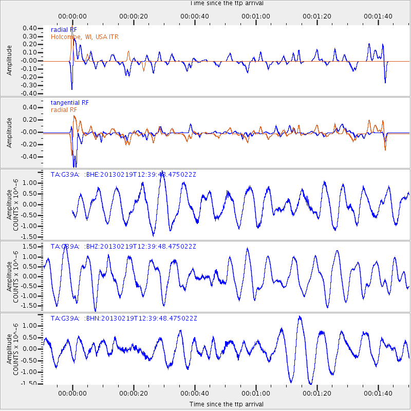
G39A Holcombe, WI, USA - Earthquake Result Viewer
*The percent match for this event was below the threshold and hence no stack was calculated.
| Earthquake location: |
Near East Coast Of Honshu, Japan |
| Earthquake latitude/longitude: |
35.3/141.0 |
| Earthquake time(UTC): |
2013/02/19 (050) 12:27:36 GMT |
| Earthquake Depth: |
20 km |
| Earthquake Magnitude: |
5.5 MB, 5.2 MS, 5.4 MW, 5.3 MW |
| Earthquake Catalog/Contributor: |
WHDF/NEIC |
|
| Network: |
TA USArray Transportable Network (new EarthScope stations) |
| Station: |
G39A Holcombe, WI, USA |
| Lat/Lon: |
45.29 N/91.17 W |
| Elevation: |
350 m |
|
| Distance: |
87.0 deg |
| Az: |
33.917 deg |
| Baz: |
319.69 deg |
| Ray Param: |
$rayparam |
*The percent match for this event was below the threshold and hence was not used in the summary stack. |
|
| Radial Match: |
50.460487 % |
| Radial Bump: |
400 |
| Transverse Match: |
81.081985 % |
| Transverse Bump: |
400 |
| SOD ConfigId: |
494114 |
| Insert Time: |
2013-05-09 04:12:04.423 +0000 |
| GWidth: |
2.5 |
| Max Bumps: |
400 |
| Tol: |
0.001 |
|
Signal To Noise
| Channel | StoN | STA | LTA |
| TA:G39A: :BHZ:20130219T12:39:48.475022Z | 1.250966 | 7.63491E-7 | 6.103212E-7 |
| TA:G39A: :BHN:20130219T12:39:48.475022Z | 0.7568239 | 3.3973376E-7 | 4.4889404E-7 |
| TA:G39A: :BHE:20130219T12:39:48.475022Z | 1.8191662 | 9.246236E-7 | 5.082678E-7 |
| Arrivals |
| Ps | |
| PpPs | |
| PsPs/PpSs | |


