You are here: Home > Network List > TA - USArray Transportable Network (new EarthScope stations) Stations List
> Station R11A Troy Canyon, Currant, NV, USA > Earthquake Result Viewer
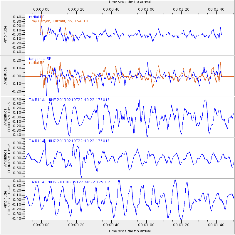
R11A Troy Canyon, Currant, NV, USA - Earthquake Result Viewer
*The percent match for this event was below the threshold and hence no stack was calculated.
| Earthquake location: |
Tonga Islands |
| Earthquake latitude/longitude: |
-17.5/-173.5 |
| Earthquake time(UTC): |
2013/02/19 (050) 22:29:02 GMT |
| Earthquake Depth: |
47 km |
| Earthquake Magnitude: |
5.7 MB, 5.3 MS, 5.7 MW, 5.8 MW |
| Earthquake Catalog/Contributor: |
WHDF/NEIC |
|
| Network: |
TA USArray Transportable Network (new EarthScope stations) |
| Station: |
R11A Troy Canyon, Currant, NV, USA |
| Lat/Lon: |
38.35 N/115.59 W |
| Elevation: |
1756 m |
|
| Distance: |
77.6 deg |
| Az: |
42.98 deg |
| Baz: |
235.855 deg |
| Ray Param: |
$rayparam |
*The percent match for this event was below the threshold and hence was not used in the summary stack. |
|
| Radial Match: |
65.511925 % |
| Radial Bump: |
400 |
| Transverse Match: |
59.28623 % |
| Transverse Bump: |
383 |
| SOD ConfigId: |
494114 |
| Insert Time: |
2013-05-09 04:21:24.979 +0000 |
| GWidth: |
2.5 |
| Max Bumps: |
400 |
| Tol: |
0.001 |
|
Signal To Noise
| Channel | StoN | STA | LTA |
| TA:R11A: :BHZ:20130219T22:40:22.17501Z | 2.5290084 | 4.6898245E-7 | 1.8544124E-7 |
| TA:R11A: :BHN:20130219T22:40:22.17501Z | 1.72402 | 1.1797747E-7 | 6.843162E-8 |
| TA:R11A: :BHE:20130219T22:40:22.17501Z | 1.1560818 | 2.2753682E-7 | 1.9681724E-7 |
| Arrivals |
| Ps | |
| PpPs | |
| PsPs/PpSs | |


