You are here: Home > Network List > TA - USArray Transportable Network (new EarthScope stations) Stations List
> Station T47A Sharon Grove, KY, USA > Earthquake Result Viewer
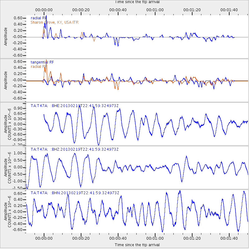
T47A Sharon Grove, KY, USA - Earthquake Result Viewer
*The percent match for this event was below the threshold and hence no stack was calculated.
| Earthquake location: |
Tonga Islands |
| Earthquake latitude/longitude: |
-17.5/-173.5 |
| Earthquake time(UTC): |
2013/02/19 (050) 22:29:02 GMT |
| Earthquake Depth: |
47 km |
| Earthquake Magnitude: |
5.7 MB, 5.3 MS, 5.7 MW, 5.8 MW |
| Earthquake Catalog/Contributor: |
WHDF/NEIC |
|
| Network: |
TA USArray Transportable Network (new EarthScope stations) |
| Station: |
T47A Sharon Grove, KY, USA |
| Lat/Lon: |
36.99 N/87.11 W |
| Elevation: |
217 m |
|
| Distance: |
97.5 deg |
| Az: |
53.697 deg |
| Baz: |
253.884 deg |
| Ray Param: |
$rayparam |
*The percent match for this event was below the threshold and hence was not used in the summary stack. |
|
| Radial Match: |
84.957344 % |
| Radial Bump: |
400 |
| Transverse Match: |
66.97116 % |
| Transverse Bump: |
400 |
| SOD ConfigId: |
494114 |
| Insert Time: |
2013-05-09 04:23:25.402 +0000 |
| GWidth: |
2.5 |
| Max Bumps: |
400 |
| Tol: |
0.001 |
|
Signal To Noise
| Channel | StoN | STA | LTA |
| TA:T47A: :BHZ:20130219T22:41:59.324973Z | 0.9574163 | 6.324666E-7 | 6.6059727E-7 |
| TA:T47A: :BHN:20130219T22:41:59.324973Z | 0.904363 | 2.8013727E-7 | 3.09762E-7 |
| TA:T47A: :BHE:20130219T22:41:59.324973Z | 1.2933636 | 6.727668E-7 | 5.201684E-7 |
| Arrivals |
| Ps | |
| PpPs | |
| PsPs/PpSs | |


