You are here: Home > Network List > GT - Global Telemetered Seismograph Network (USAF/USGS) Stations List
> Station CPUP Villa Florida, Paraguay > Earthquake Result Viewer
CPUP Villa Florida, Paraguay - Earthquake Result Viewer
| Earthquake location: |
South Sandwich Islands Region |
| Earthquake latitude/longitude: |
-56.0/-28.0 |
| Earthquake time(UTC): |
2008/04/14 (105) 09:45:19 GMT |
| Earthquake Depth: |
140 km |
| Earthquake Magnitude: |
6.0 MB, 6.0 MW, 6.0 MW |
| Earthquake Catalog/Contributor: |
WHDF/NEIC |
|
| Network: |
GT Global Telemetered Seismograph Network (USAF/USGS) |
| Station: |
CPUP Villa Florida, Paraguay |
| Lat/Lon: |
26.33 S/57.33 W |
| Elevation: |
105 m |
|
| Distance: |
36.4 deg |
| Az: |
312.327 deg |
| Baz: |
152.449 deg |
| Ray Param: |
0.076198146 |
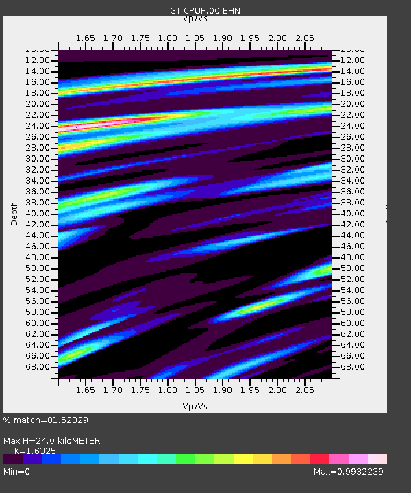
| Estimated Moho Depth: |
24.0 km |
| Estimated Crust Vp/Vs: |
1.63 |
| Assumed Crust Vp: |
6.498 km/s |
| Estimated Crust Vs: |
3.98 km/s |
| Estimated Crust Poisson's Ratio: |
0.20 |
|
| Radial Match: |
81.52329 % |
| Radial Bump: |
367 |
| Transverse Match: |
65.0286 % |
| Transverse Bump: |
400 |
| SOD ConfigId: |
2504 |
| Insert Time: |
2010-02-27 01:51:21.389 +0000 |
| GWidth: |
2.5 |
| Max Bumps: |
400 |
| Tol: |
0.001 |
|

Signal To Noise
| Channel | StoN | STA | LTA |
| GT:CPUP:00:BHN:20080414T09:51:40.575Z | 15.884218 | 7.5666213E-7 | 4.7636096E-8 |
| GT:CPUP:00:BHE:20080414T09:51:40.575Z | 9.957007 | 3.403126E-7 | 3.41782E-8 |
| GT:CPUP:00:BHZ:20080414T09:51:40.575Z | 8.783385 | 3.3120773E-7 | 3.7708435E-8 |
| Arrivals |
| Ps | 2.5 SECOND |
| PpPs | 9.0 SECOND |
| PsPs/PpSs | 11 SECOND |


