You are here: Home > Network List > TA - USArray Transportable Network (new EarthScope stations) Stations List
> Station G59A Clarenceville, QC, USA > Earthquake Result Viewer
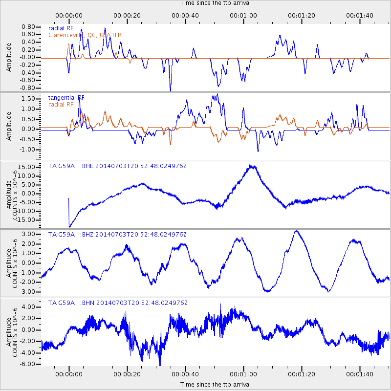
G59A Clarenceville, QC, USA - Earthquake Result Viewer
*The percent match for this event was below the threshold and hence no stack was calculated.
| Earthquake location: |
Eastern Kashmir |
| Earthquake latitude/longitude: |
35.6/75.1 |
| Earthquake time(UTC): |
2014/07/03 (184) 20:40:01 GMT |
| Earthquake Depth: |
35 km |
| Earthquake Magnitude: |
4.9 mb |
| Earthquake Catalog/Contributor: |
ISC/ISC |
|
| Network: |
TA USArray Transportable Network (new EarthScope stations) |
| Station: |
G59A Clarenceville, QC, USA |
| Lat/Lon: |
45.08 N/73.18 W |
| Elevation: |
36 m |
|
| Distance: |
94.8 deg |
| Az: |
338.046 deg |
| Baz: |
25.485 deg |
| Ray Param: |
$rayparam |
*The percent match for this event was below the threshold and hence was not used in the summary stack. |
|
| Radial Match: |
47.870544 % |
| Radial Bump: |
400 |
| Transverse Match: |
31.156162 % |
| Transverse Bump: |
400 |
| SOD ConfigId: |
3390531 |
| Insert Time: |
2019-04-12 16:31:04.010 +0000 |
| GWidth: |
2.5 |
| Max Bumps: |
400 |
| Tol: |
0.001 |
|
Signal To Noise
| Channel | StoN | STA | LTA |
| TA:G59A: :BHZ:20140703T20:52:48.024976Z | 1.6222303 | 1.3741234E-6 | 8.470581E-7 |
| TA:G59A: :BHN:20140703T20:52:48.024976Z | 0.3909706 | 2.3983123E-6 | 6.134252E-6 |
| TA:G59A: :BHE:20140703T20:52:48.024976Z | 0.85176533 | 5.343109E-6 | 6.2729823E-6 |
| Arrivals |
| Ps | |
| PpPs | |
| PsPs/PpSs | |


