CPUP Villa Florida, Paraguay - Earthquake Result Viewer
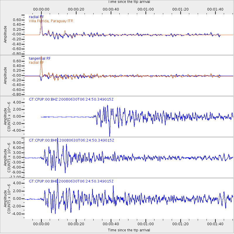
Earthquake location: South Sandwich Islands Region
Earthquake latitude/longitude: -58.2/-22.1
Earthquake time(UTC): 2008/06/30 (182) 06:17:44 GMT
Earthquake Depth: 19 km
Earthquake Magnitude: 6.1 MB, 6.7 MS, 7.0 MW, 6.9 MW
Earthquake Catalog/Contributor: WHDF/NEIC
Network: GT Global Telemetered Seismograph Network (USAF/USGS)
Station: CPUP Villa Florida, Paraguay
Lat/Lon: 26.33 S/57.33 W
Elevation: 105 m
Distance: 40.3 deg
Az: 306.887 deg
Baz: 151.858 deg
Ray Param: 0.07443657
Estimated Moho Depth: 66.5 km
Estimated Crust Vp/Vs: 1.60
Assumed Crust Vp: 6.498 km/s
Estimated Crust Vs: 4.055 km/s
Estimated Crust Poisson's Ratio: 0.18
Radial Match: 96.422714 %
Radial Bump: 384
Transverse Match: 91.68395 %
Transverse Bump: 400
SOD ConfigId: 2504
Insert Time: 2010-02-27 01:51:29.953 +0000
GWidth: 2.5
Max Bumps: 400
Tol: 0.001

Signal To Noise

ChannelStoNSTALTA
GT:CPUP:00:BHN:20080630T06:24:50.349015Z53.9747662.5196343E-64.668171E-8
GT:CPUP:00:BHE:20080630T06:24:50.349015Z28.1669981.1299538E-64.0116234E-8
GT:CPUP:00:BHZ:20080630T06:24:50.349015Z33.7759781.0891706E-63.2246902E-8
Arrivals
Ps6.7 SECOND
PpPs25 SECOND
PsPs/PpSs31 SECOND