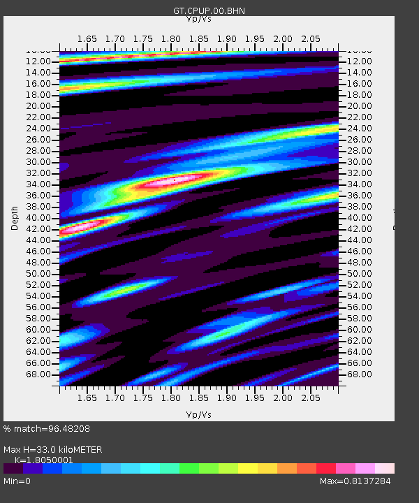
CPUP Villa Florida, Paraguay - Earthquake Result Viewer

Earthquake location: Near Coast Of Chiapas, Mexico
Earthquake latitude/longitude: 14.4/-92.4
Earthquake time(UTC): 2008/10/16 (290) 19:41:25 GMT
Earthquake Depth: 24 km
Earthquake Magnitude: 6.1 MB, 6.6 MS, 6.7 MW, 6.6 MW
Earthquake Catalog/Contributor: WHDF/NEIC
Network: GT Global Telemetered Seismograph Network (USAF/USGS)
Station: CPUP Villa Florida, Paraguay
Lat/Lon: 26.33 S/57.33 W
Elevation: 105 m
Distance: 52.9 deg
Az: 139.786 deg
Baz: 315.809 deg
Ray Param: 0.06640295
Estimated Moho Depth: 33.0 km
Estimated Crust Vp/Vs: 1.81
Assumed Crust Vp: 6.498 km/s
Estimated Crust Vs: 3.6 km/s
Estimated Crust Poisson's Ratio: 0.28
Radial Match: 96.48208 %
Radial Bump: 337
Transverse Match: 87.08275 %
Transverse Bump: 400
SOD ConfigId: 2560
Insert Time: 2010-02-27 01:51:36.273 +0000
GWidth: 2.5
Max Bumps: 400
Tol: 0.001

Signal To Noise

ChannelStoNSTALTA
GT:CPUP:00:BHN:20081016T19:50:09.050017Z13.038555.7505235E-74.410401E-8
GT:CPUP:00:BHE:20081016T19:50:09.050017Z6.611051.9734846E-72.9851304E-8
GT:CPUP:00:BHZ:20081016T19:50:09.050017Z6.8975672.3968232E-73.4748822E-8
Arrivals
Ps4.3 SECOND
PpPs13 SECOND
PsPs/PpSs18 SECOND