You are here: Home > Network List > G - GEOSCOPE Stations List
> Station FDF Fort de France, Martinique France > Earthquake Result Viewer
FDF Fort de France, Martinique France - Earthquake Result Viewer
| Earthquake location: |
Santiago Del Estero Prov., Arg. |
| Earthquake latitude/longitude: |
-27.9/-63.1 |
| Earthquake time(UTC): |
2013/02/22 (053) 12:01:58 GMT |
| Earthquake Depth: |
575 km |
| Earthquake Magnitude: |
5.8 MB, 6.1 MW, 6.2 MW |
| Earthquake Catalog/Contributor: |
WHDF/NEIC |
|
| Network: |
G GEOSCOPE |
| Station: |
FDF Fort de France, Martinique France |
| Lat/Lon: |
14.73 N/61.14 W |
| Elevation: |
467 m |
|
| Distance: |
42.5 deg |
| Az: |
2.801 deg |
| Baz: |
182.562 deg |
| Ray Param: |
0.07025655 |
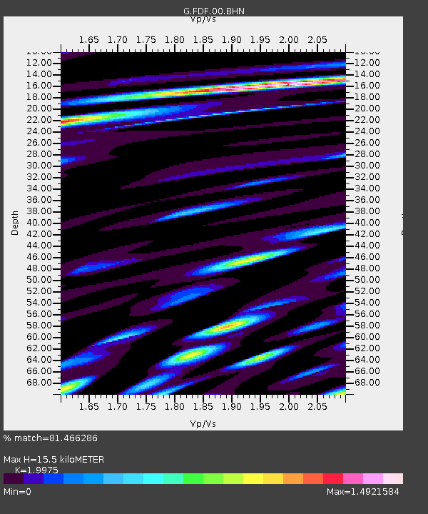
| Estimated Moho Depth: |
15.5 km |
| Estimated Crust Vp/Vs: |
2.00 |
| Assumed Crust Vp: |
5.88 km/s |
| Estimated Crust Vs: |
2.944 km/s |
| Estimated Crust Poisson's Ratio: |
0.33 |
|
| Radial Match: |
81.466286 % |
| Radial Bump: |
400 |
| Transverse Match: |
67.71281 % |
| Transverse Bump: |
400 |
| SOD ConfigId: |
494114 |
| Insert Time: |
2013-05-09 04:39:55.173 +0000 |
| GWidth: |
2.5 |
| Max Bumps: |
400 |
| Tol: |
0.001 |
|
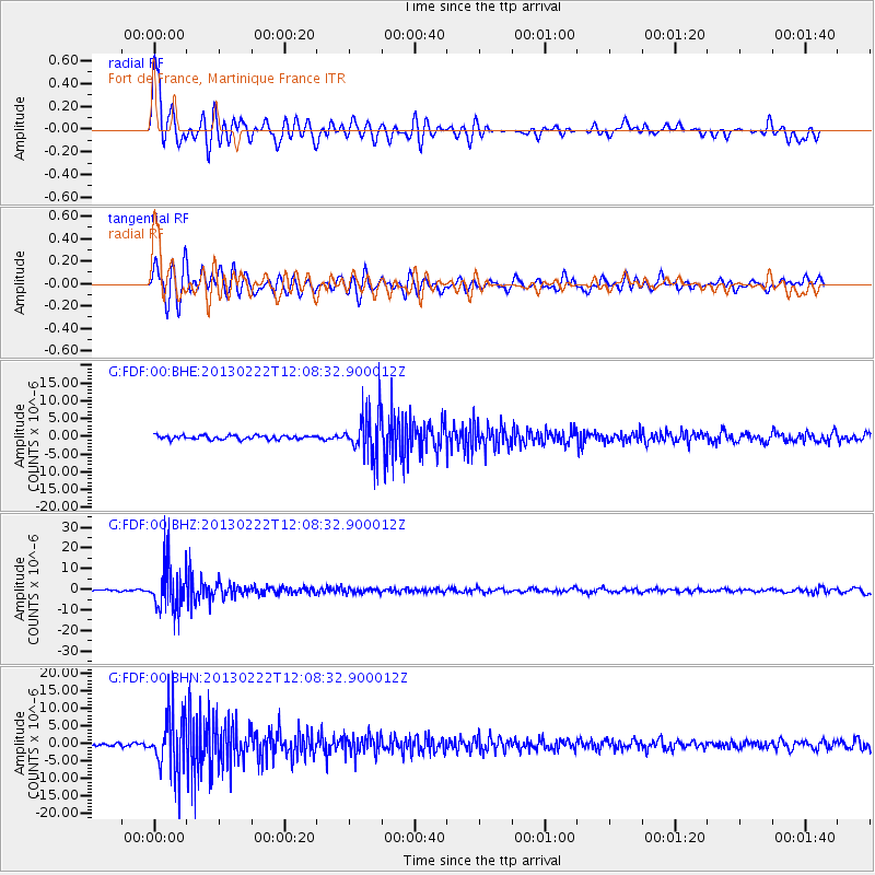
Signal To Noise
| Channel | StoN | STA | LTA |
| G:FDF:00:BHZ:20130222T12:08:32.900012Z | 26.210562 | 1.1085101E-5 | 4.2292496E-7 |
| G:FDF:00:BHN:20130222T12:08:32.900012Z | 17.615536 | 8.227835E-6 | 4.670783E-7 |
| G:FDF:00:BHE:20130222T12:08:32.900012Z | 11.530513 | 6.077197E-6 | 5.270535E-7 |
| Arrivals |
| Ps | 2.8 SECOND |
| PpPs | 7.6 SECOND |
| PsPs/PpSs | 10 SECOND |


