You are here: Home > Network List > NM - Cooperative New Madrid Seismic Network Stations List
> Station PVMO UM Delta Research Portageville, MO > Earthquake Result Viewer
PVMO UM Delta Research Portageville, MO - Earthquake Result Viewer
| Earthquake location: |
Santiago Del Estero Prov., Arg. |
| Earthquake latitude/longitude: |
-27.9/-63.1 |
| Earthquake time(UTC): |
2013/02/22 (053) 12:01:58 GMT |
| Earthquake Depth: |
575 km |
| Earthquake Magnitude: |
5.8 MB, 6.1 MW, 6.2 MW |
| Earthquake Catalog/Contributor: |
WHDF/NEIC |
|
| Network: |
NM Cooperative New Madrid Seismic Network |
| Station: |
PVMO UM Delta Research Portageville, MO |
| Lat/Lon: |
36.41 N/89.70 W |
| Elevation: |
98 m |
|
| Distance: |
68.7 deg |
| Az: |
337.193 deg |
| Baz: |
154.838 deg |
| Ray Param: |
0.054092642 |
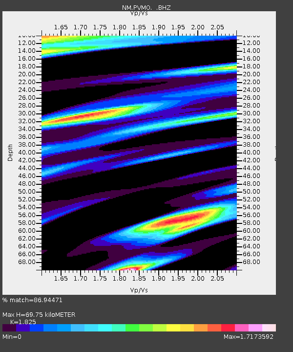
| Estimated Moho Depth: |
69.75 km |
| Estimated Crust Vp/Vs: |
1.83 |
| Assumed Crust Vp: |
6.444 km/s |
| Estimated Crust Vs: |
3.531 km/s |
| Estimated Crust Poisson's Ratio: |
0.29 |
|
| Radial Match: |
86.94471 % |
| Radial Bump: |
400 |
| Transverse Match: |
71.36621 % |
| Transverse Bump: |
400 |
| SOD ConfigId: |
494114 |
| Insert Time: |
2013-05-09 04:44:10.138 +0000 |
| GWidth: |
2.5 |
| Max Bumps: |
400 |
| Tol: |
0.001 |
|

Signal To Noise
| Channel | StoN | STA | LTA |
| NM:PVMO: :BHZ:20130222T12:11:34.174976Z | 6.784392 | 7.313721E-6 | 1.0780216E-6 |
| NM:PVMO: :BHN:20130222T12:11:34.174976Z | 3.4196854 | 4.5566253E-6 | 1.3324692E-6 |
| NM:PVMO: :BHE:20130222T12:11:34.174976Z | 1.8369364 | 2.7096057E-6 | 1.4750678E-6 |
| Arrivals |
| Ps | 9.2 SECOND |
| PpPs | 30 SECOND |
| PsPs/PpSs | 39 SECOND |


