You are here: Home > Network List > TA - USArray Transportable Network (new EarthScope stations) Stations List
> Station V45A Humboldt, TN, USA > Earthquake Result Viewer
V45A Humboldt, TN, USA - Earthquake Result Viewer
| Earthquake location: |
Santiago Del Estero Prov., Arg. |
| Earthquake latitude/longitude: |
-27.9/-63.1 |
| Earthquake time(UTC): |
2013/02/22 (053) 12:01:58 GMT |
| Earthquake Depth: |
575 km |
| Earthquake Magnitude: |
5.8 MB, 6.1 MW, 6.2 MW |
| Earthquake Catalog/Contributor: |
WHDF/NEIC |
|
| Network: |
TA USArray Transportable Network (new EarthScope stations) |
| Station: |
V45A Humboldt, TN, USA |
| Lat/Lon: |
35.74 N/88.96 W |
| Elevation: |
126 m |
|
| Distance: |
67.9 deg |
| Az: |
337.475 deg |
| Baz: |
155.376 deg |
| Ray Param: |
0.054630365 |
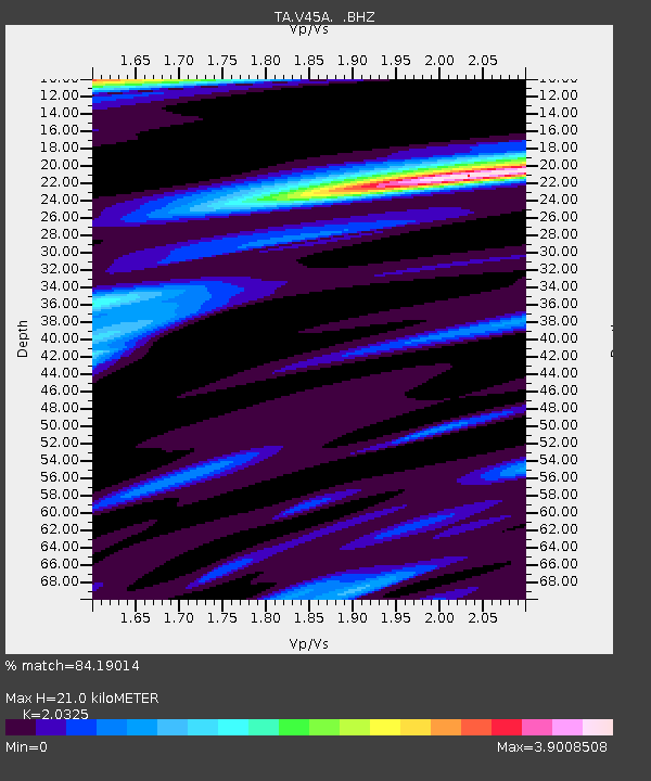
| Estimated Moho Depth: |
21.0 km |
| Estimated Crust Vp/Vs: |
2.03 |
| Assumed Crust Vp: |
6.38 km/s |
| Estimated Crust Vs: |
3.139 km/s |
| Estimated Crust Poisson's Ratio: |
0.34 |
|
| Radial Match: |
84.19014 % |
| Radial Bump: |
357 |
| Transverse Match: |
76.30928 % |
| Transverse Bump: |
400 |
| SOD ConfigId: |
494114 |
| Insert Time: |
2013-05-09 04:50:03.743 +0000 |
| GWidth: |
2.5 |
| Max Bumps: |
400 |
| Tol: |
0.001 |
|
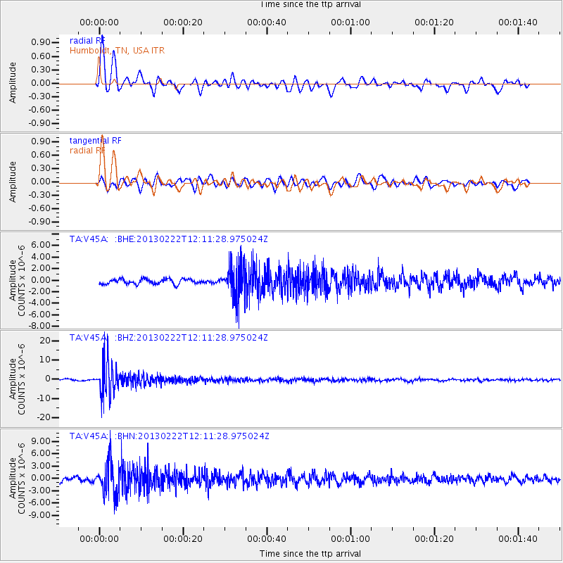
Signal To Noise
| Channel | StoN | STA | LTA |
| TA:V45A: :BHZ:20130222T12:11:28.975024Z | 26.89006 | 8.358906E-6 | 3.1085486E-7 |
| TA:V45A: :BHN:20130222T12:11:28.975024Z | 7.19688 | 4.064244E-6 | 5.6472305E-7 |
| TA:V45A: :BHE:20130222T12:11:28.975024Z | 6.7248497 | 2.9051378E-6 | 4.320004E-7 |
| Arrivals |
| Ps | 3.5 SECOND |
| PpPs | 9.7 SECOND |
| PsPs/PpSs | 13 SECOND |


