You are here: Home > Network List > TA - USArray Transportable Network (new EarthScope stations) Stations List
> Station G43A Wallace, MI, USA > Earthquake Result Viewer
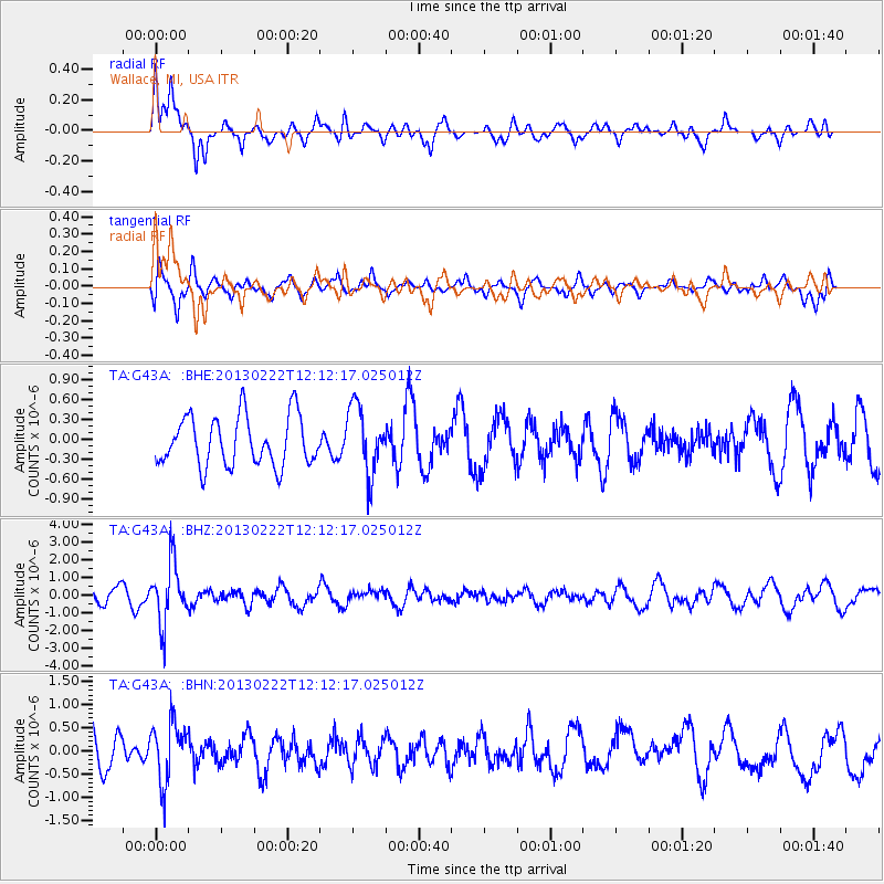
G43A Wallace, MI, USA - Earthquake Result Viewer
*The percent match for this event was below the threshold and hence no stack was calculated.
| Earthquake location: |
Santiago Del Estero Prov., Arg. |
| Earthquake latitude/longitude: |
-27.9/-63.1 |
| Earthquake time(UTC): |
2013/02/22 (053) 12:01:58 GMT |
| Earthquake Depth: |
575 km |
| Earthquake Magnitude: |
5.8 MB, 6.1 MW, 6.2 MW |
| Earthquake Catalog/Contributor: |
WHDF/NEIC |
|
| Network: |
TA USArray Transportable Network (new EarthScope stations) |
| Station: |
G43A Wallace, MI, USA |
| Lat/Lon: |
45.26 N/87.69 W |
| Elevation: |
213 m |
|
| Distance: |
76.2 deg |
| Az: |
342.385 deg |
| Baz: |
157.722 deg |
| Ray Param: |
$rayparam |
*The percent match for this event was below the threshold and hence was not used in the summary stack. |
|
| Radial Match: |
69.45579 % |
| Radial Bump: |
400 |
| Transverse Match: |
59.106598 % |
| Transverse Bump: |
400 |
| SOD ConfigId: |
494114 |
| Insert Time: |
2013-05-09 04:56:02.559 +0000 |
| GWidth: |
2.5 |
| Max Bumps: |
400 |
| Tol: |
0.001 |
|
Signal To Noise
| Channel | StoN | STA | LTA |
| TA:G43A: :BHZ:20130222T12:12:17.025012Z | 4.1879954 | 1.7044127E-6 | 4.0697574E-7 |
| TA:G43A: :BHN:20130222T12:12:17.025012Z | 2.0611002 | 6.3781584E-7 | 3.0945407E-7 |
| TA:G43A: :BHE:20130222T12:12:17.025012Z | 1.3786434 | 5.14293E-7 | 3.7304278E-7 |
| Arrivals |
| Ps | |
| PpPs | |
| PsPs/PpSs | |


