You are here: Home > Network List > TA - USArray Transportable Network (new EarthScope stations) Stations List
> Station G42A Mountain, WI, USA > Earthquake Result Viewer
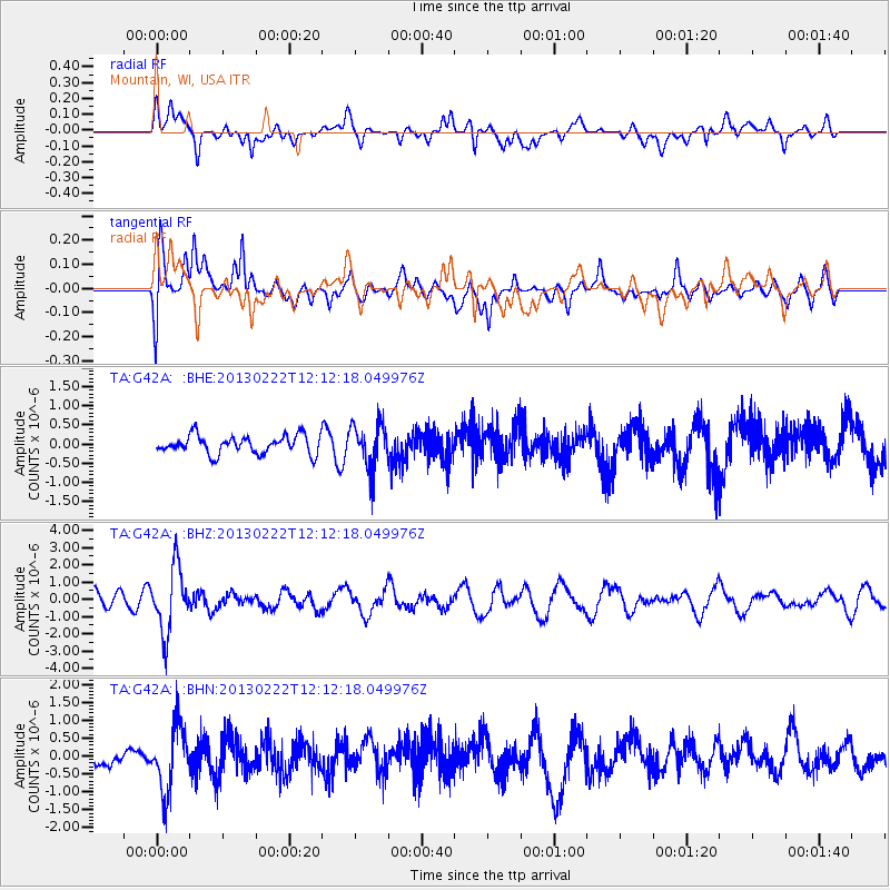
G42A Mountain, WI, USA - Earthquake Result Viewer
*The percent match for this event was below the threshold and hence no stack was calculated.
| Earthquake location: |
Santiago Del Estero Prov., Arg. |
| Earthquake latitude/longitude: |
-27.9/-63.1 |
| Earthquake time(UTC): |
2013/02/22 (053) 12:01:58 GMT |
| Earthquake Depth: |
575 km |
| Earthquake Magnitude: |
5.8 MB, 6.1 MW, 6.2 MW |
| Earthquake Catalog/Contributor: |
WHDF/NEIC |
|
| Network: |
TA USArray Transportable Network (new EarthScope stations) |
| Station: |
G42A Mountain, WI, USA |
| Lat/Lon: |
45.24 N/88.43 W |
| Elevation: |
315 m |
|
| Distance: |
76.4 deg |
| Az: |
341.881 deg |
| Baz: |
157.078 deg |
| Ray Param: |
$rayparam |
*The percent match for this event was below the threshold and hence was not used in the summary stack. |
|
| Radial Match: |
61.09146 % |
| Radial Bump: |
400 |
| Transverse Match: |
72.78973 % |
| Transverse Bump: |
400 |
| SOD ConfigId: |
494114 |
| Insert Time: |
2013-05-09 04:56:56.431 +0000 |
| GWidth: |
2.5 |
| Max Bumps: |
400 |
| Tol: |
0.001 |
|
Signal To Noise
| Channel | StoN | STA | LTA |
| TA:G42A: :BHZ:20130222T12:12:18.049976Z | 3.732557 | 1.8775398E-6 | 5.030171E-7 |
| TA:G42A: :BHN:20130222T12:12:18.049976Z | 2.635319 | 8.9993205E-7 | 3.4148886E-7 |
| TA:G42A: :BHE:20130222T12:12:18.049976Z | 2.4343028 | 5.7314094E-7 | 2.3544358E-7 |
| Arrivals |
| Ps | |
| PpPs | |
| PsPs/PpSs | |


