You are here: Home > Network List > TA - USArray Transportable Network (new EarthScope stations) Stations List
> Station W48A Pulaski, TN, USA > Earthquake Result Viewer
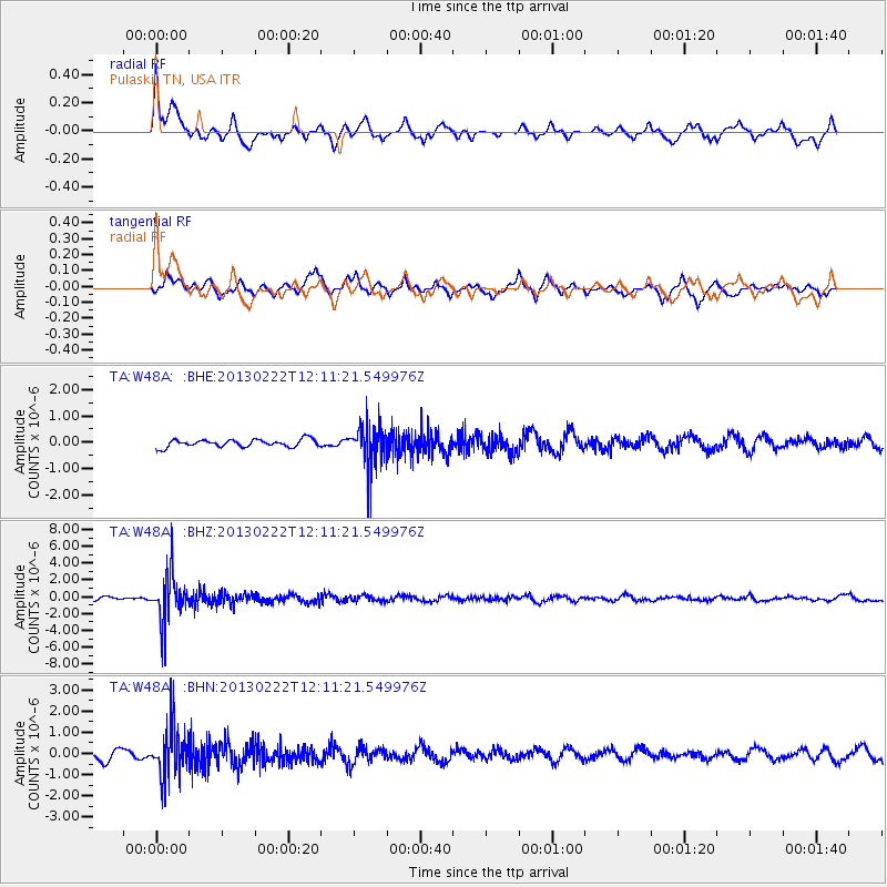
W48A Pulaski, TN, USA - Earthquake Result Viewer
*The percent match for this event was below the threshold and hence no stack was calculated.
| Earthquake location: |
Santiago Del Estero Prov., Arg. |
| Earthquake latitude/longitude: |
-27.9/-63.1 |
| Earthquake time(UTC): |
2013/02/22 (053) 12:01:58 GMT |
| Earthquake Depth: |
575 km |
| Earthquake Magnitude: |
5.8 MB, 6.1 MW, 6.2 MW |
| Earthquake Catalog/Contributor: |
WHDF/NEIC |
|
| Network: |
TA USArray Transportable Network (new EarthScope stations) |
| Station: |
W48A Pulaski, TN, USA |
| Lat/Lon: |
35.14 N/86.93 W |
| Elevation: |
260 m |
|
| Distance: |
66.7 deg |
| Az: |
338.854 deg |
| Baz: |
157.079 deg |
| Ray Param: |
$rayparam |
*The percent match for this event was below the threshold and hence was not used in the summary stack. |
|
| Radial Match: |
67.471924 % |
| Radial Bump: |
400 |
| Transverse Match: |
77.8307 % |
| Transverse Bump: |
400 |
| SOD ConfigId: |
494114 |
| Insert Time: |
2013-05-09 05:01:19.585 +0000 |
| GWidth: |
2.5 |
| Max Bumps: |
400 |
| Tol: |
0.001 |
|
Signal To Noise
| Channel | StoN | STA | LTA |
| TA:W48A: :BHZ:20130222T12:11:21.549976Z | 11.155172 | 2.8559396E-6 | 2.5601932E-7 |
| TA:W48A: :BHN:20130222T12:11:21.549976Z | 5.1096587 | 1.1918262E-6 | 2.3324966E-7 |
| TA:W48A: :BHE:20130222T12:11:21.549976Z | 5.3449073 | 7.631077E-7 | 1.4277286E-7 |
| Arrivals |
| Ps | |
| PpPs | |
| PsPs/PpSs | |


