You are here: Home > Network List > 1U - Mt. Paektu Seismic Network Stations List
> Station SHRD Sin Hung Ri > Earthquake Result Viewer
SHRD Sin Hung Ri - Earthquake Result Viewer
| Earthquake location: |
New Britain Region, P.N.G. |
| Earthquake latitude/longitude: |
-6.2/152.8 |
| Earthquake time(UTC): |
2014/07/04 (185) 15:00:26 GMT |
| Earthquake Depth: |
10 km |
| Earthquake Magnitude: |
6.6 MWP, 6.7 MI |
| Earthquake Catalog/Contributor: |
NEIC PDE/NEIC COMCAT |
|
| Network: |
1U Mt. Paektu Seismic Network |
| Station: |
SHRD Sin Hung Ri |
| Lat/Lon: |
41.95 N/128.79 E |
| Elevation: |
1041 m |
|
| Distance: |
52.7 deg |
| Az: |
337.551 deg |
| Baz: |
149.409 deg |
| Ray Param: |
0.06658836 |
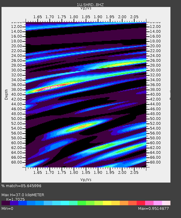
| Estimated Moho Depth: |
37.0 km |
| Estimated Crust Vp/Vs: |
1.70 |
| Assumed Crust Vp: |
6.472 km/s |
| Estimated Crust Vs: |
3.801 km/s |
| Estimated Crust Poisson's Ratio: |
0.24 |
|
| Radial Match: |
85.645996 % |
| Radial Bump: |
400 |
| Transverse Match: |
37.632248 % |
| Transverse Bump: |
400 |
| SOD ConfigId: |
3390531 |
| Insert Time: |
2019-04-12 16:43:51.175 +0000 |
| GWidth: |
2.5 |
| Max Bumps: |
400 |
| Tol: |
0.001 |
|

Signal To Noise
| Channel | StoN | STA | LTA |
| 1U:SHRD: :BHZ:20140704T15:09:10.180Z | 33.45169 | 2.4308613E-6 | 7.266782E-8 |
| 1U:SHRD: :BHN:20140704T15:09:10.180Z | 7.5431337 | 9.867964E-7 | 1.3082048E-7 |
| 1U:SHRD: :BHE:20140704T15:09:10.180Z | 1.5333406 | 1.183142E-6 | 7.716107E-7 |
| Arrivals |
| Ps | 4.3 SECOND |
| PpPs | 15 SECOND |
| PsPs/PpSs | 19 SECOND |


