You are here: Home > Network List > TA - USArray Transportable Network (new EarthScope stations) Stations List
> Station L48A N Adams, MI, USA > Earthquake Result Viewer
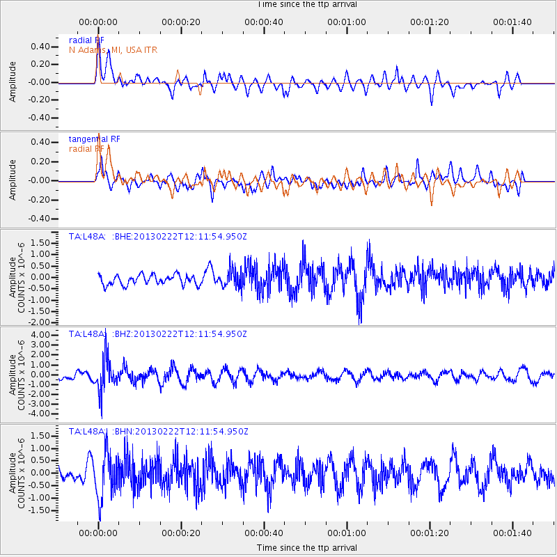
L48A N Adams, MI, USA - Earthquake Result Viewer
*The percent match for this event was below the threshold and hence no stack was calculated.
| Earthquake location: |
Santiago Del Estero Prov., Arg. |
| Earthquake latitude/longitude: |
-27.9/-63.1 |
| Earthquake time(UTC): |
2013/02/22 (053) 12:01:58 GMT |
| Earthquake Depth: |
575 km |
| Earthquake Magnitude: |
5.8 MB, 6.1 MW, 6.2 MW |
| Earthquake Catalog/Contributor: |
WHDF/NEIC |
|
| Network: |
TA USArray Transportable Network (new EarthScope stations) |
| Station: |
L48A N Adams, MI, USA |
| Lat/Lon: |
41.94 N/84.43 W |
| Elevation: |
369 m |
|
| Distance: |
72.3 deg |
| Az: |
343.443 deg |
| Baz: |
160.246 deg |
| Ray Param: |
$rayparam |
*The percent match for this event was below the threshold and hence was not used in the summary stack. |
|
| Radial Match: |
63.950245 % |
| Radial Bump: |
400 |
| Transverse Match: |
66.8969 % |
| Transverse Bump: |
400 |
| SOD ConfigId: |
494114 |
| Insert Time: |
2013-05-09 05:10:53.022 +0000 |
| GWidth: |
2.5 |
| Max Bumps: |
400 |
| Tol: |
0.001 |
|
Signal To Noise
| Channel | StoN | STA | LTA |
| TA:L48A: :BHZ:20130222T12:11:54.950Z | 4.5784817 | 1.6461213E-6 | 3.595343E-7 |
| TA:L48A: :BHN:20130222T12:11:54.950Z | 2.4272168 | 9.2855623E-7 | 3.8256005E-7 |
| TA:L48A: :BHE:20130222T12:11:54.950Z | 1.8466967 | 3.9585558E-7 | 2.1435874E-7 |
| Arrivals |
| Ps | |
| PpPs | |
| PsPs/PpSs | |


