You are here: Home > Network List > TA - USArray Transportable Network (new EarthScope stations) Stations List
> Station D51A Lot 18 Range III Mazenod Township, QC, CAN > Earthquake Result Viewer
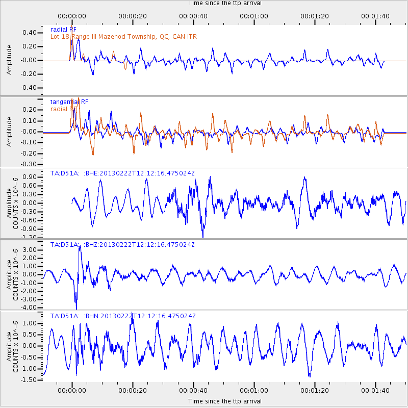
D51A Lot 18 Range III Mazenod Township, QC, CAN - Earthquake Result Viewer
*The percent match for this event was below the threshold and hence no stack was calculated.
| Earthquake location: |
Santiago Del Estero Prov., Arg. |
| Earthquake latitude/longitude: |
-27.9/-63.1 |
| Earthquake time(UTC): |
2013/02/22 (053) 12:01:58 GMT |
| Earthquake Depth: |
575 km |
| Earthquake Magnitude: |
5.8 MB, 6.1 MW, 6.2 MW |
| Earthquake Catalog/Contributor: |
WHDF/NEIC |
|
| Network: |
TA USArray Transportable Network (new EarthScope stations) |
| Station: |
D51A Lot 18 Range III Mazenod Township, QC, CAN |
| Lat/Lon: |
47.09 N/79.37 W |
| Elevation: |
282 m |
|
| Distance: |
76.1 deg |
| Az: |
348.622 deg |
| Baz: |
165.199 deg |
| Ray Param: |
$rayparam |
*The percent match for this event was below the threshold and hence was not used in the summary stack. |
|
| Radial Match: |
54.03176 % |
| Radial Bump: |
302 |
| Transverse Match: |
59.84906 % |
| Transverse Bump: |
289 |
| SOD ConfigId: |
494114 |
| Insert Time: |
2013-05-09 05:13:43.807 +0000 |
| GWidth: |
2.5 |
| Max Bumps: |
400 |
| Tol: |
0.001 |
|
Signal To Noise
| Channel | StoN | STA | LTA |
| TA:D51A: :BHZ:20130222T12:12:16.475024Z | 5.2192326 | 1.7899685E-6 | 3.4295627E-7 |
| TA:D51A: :BHN:20130222T12:12:16.475024Z | 1.0555161 | 5.9547244E-7 | 5.641528E-7 |
| TA:D51A: :BHE:20130222T12:12:16.475024Z | 0.69625634 | 2.5429006E-7 | 3.6522476E-7 |
| Arrivals |
| Ps | |
| PpPs | |
| PsPs/PpSs | |


