You are here: Home > Network List > TA - USArray Transportable Network (new EarthScope stations) Stations List
> Station Q54A Coxs Mills, WV, USA > Earthquake Result Viewer
Q54A Coxs Mills, WV, USA - Earthquake Result Viewer
*The percent match for this event was below the threshold and hence no stack was calculated.
| Earthquake location: |
Santiago Del Estero Prov., Arg. |
| Earthquake latitude/longitude: |
-27.9/-63.1 |
| Earthquake time(UTC): |
2013/02/22 (053) 12:01:58 GMT |
| Earthquake Depth: |
575 km |
| Earthquake Magnitude: |
5.8 MB, 6.1 MW, 6.2 MW |
| Earthquake Catalog/Contributor: |
WHDF/NEIC |
|
| Network: |
TA USArray Transportable Network (new EarthScope stations) |
| Station: |
Q54A Coxs Mills, WV, USA |
| Lat/Lon: |
38.98 N/80.83 W |
| Elevation: |
254 m |
|
| Distance: |
68.6 deg |
| Az: |
345.225 deg |
| Baz: |
163.171 deg |
| Ray Param: |
$rayparam |
*The percent match for this event was below the threshold and hence was not used in the summary stack. |
|
| Radial Match: |
51.384304 % |
| Radial Bump: |
400 |
| Transverse Match: |
56.090214 % |
| Transverse Bump: |
364 |
| SOD ConfigId: |
494114 |
| Insert Time: |
2013-05-09 05:18:24.340 +0000 |
| GWidth: |
2.5 |
| Max Bumps: |
400 |
| Tol: |
0.001 |
|
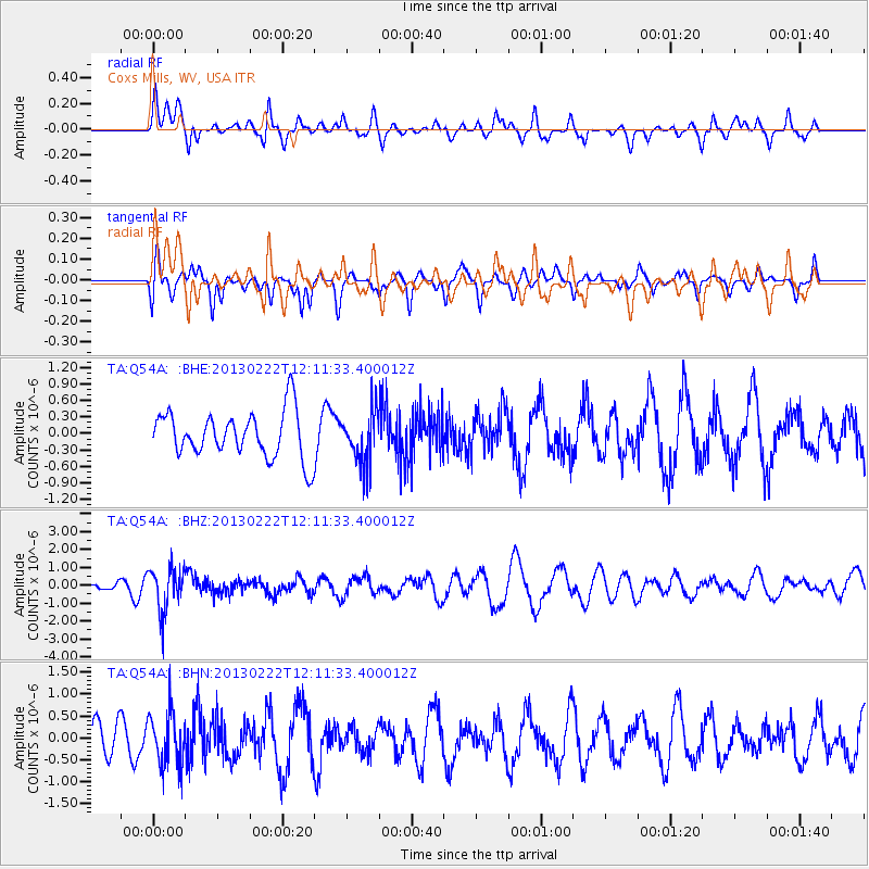
Signal To Noise
| Channel | StoN | STA | LTA |
| TA:Q54A: :BHZ:20130222T12:11:33.400012Z | 4.568944 | 1.2362211E-6 | 2.705704E-7 |
| TA:Q54A: :BHN:20130222T12:11:33.400012Z | 1.363176 | 5.955071E-7 | 4.368527E-7 |
| TA:Q54A: :BHE:20130222T12:11:33.400012Z | 1.0749147 | 4.5228566E-7 | 4.2076422E-7 |
| Arrivals |
| Ps | |
| PpPs | |
| PsPs/PpSs | |


