You are here: Home > Network List > XD14 - Illuminating the architecture of the greater Mount St. Helens magmatic systems f Stations List
> Station MG05 "Mount St Helens, WA" > Earthquake Result Viewer
MG05 "Mount St Helens, WA" - Earthquake Result Viewer
| Earthquake location: |
New Britain Region, P.N.G. |
| Earthquake latitude/longitude: |
-6.2/152.8 |
| Earthquake time(UTC): |
2014/07/04 (185) 15:00:26 GMT |
| Earthquake Depth: |
10 km |
| Earthquake Magnitude: |
6.6 MWP, 6.7 MI |
| Earthquake Catalog/Contributor: |
NEIC PDE/NEIC COMCAT |
|
| Network: |
XD Illuminating the architecture of the greater Mount St. Helens magmatic systems f |
| Station: |
MG05 "Mount St Helens, WA" |
| Lat/Lon: |
46.31 N/122.34 W |
| Elevation: |
1283 m |
|
| Distance: |
90.9 deg |
| Az: |
43.67 deg |
| Baz: |
262.014 deg |
| Ray Param: |
0.041641828 |
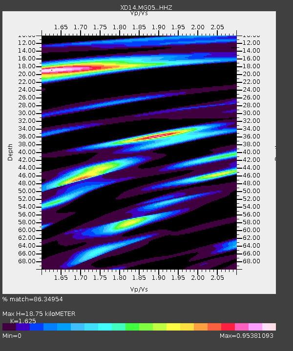
| Estimated Moho Depth: |
18.75 km |
| Estimated Crust Vp/Vs: |
1.62 |
| Assumed Crust Vp: |
6.566 km/s |
| Estimated Crust Vs: |
4.041 km/s |
| Estimated Crust Poisson's Ratio: |
0.20 |
|
| Radial Match: |
86.34954 % |
| Radial Bump: |
378 |
| Transverse Match: |
67.40751 % |
| Transverse Bump: |
400 |
| SOD ConfigId: |
3390531 |
| Insert Time: |
2019-04-12 16:47:26.881 +0000 |
| GWidth: |
2.5 |
| Max Bumps: |
400 |
| Tol: |
0.001 |
|

Signal To Noise
| Channel | StoN | STA | LTA |
| XD:MG05: :HHZ:20140704T15:12:58.53498Z | 11.0199795 | 9.5306217E-7 | 8.648494E-8 |
| XD:MG05: :HHN:20140704T15:12:58.53498Z | 1.9156374 | 2.3177029E-7 | 1.209886E-7 |
| XD:MG05: :HHE:20140704T15:12:58.53498Z | 7.2152634 | 4.334888E-7 | 6.0079415E-8 |
| Arrivals |
| Ps | 1.8 SECOND |
| PpPs | 7.3 SECOND |
| PsPs/PpSs | 9.1 SECOND |


