You are here: Home > Network List > TA - USArray Transportable Network (new EarthScope stations) Stations List
> Station H17A Grant Village (NPS), Yellowstone Nt. Park, WY, USA > Earthquake Result Viewer
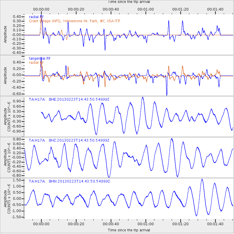
H17A Grant Village (NPS), Yellowstone Nt. Park, WY, USA - Earthquake Result Viewer
*The percent match for this event was below the threshold and hence no stack was calculated.
| Earthquake location: |
Santa Cruz Islands |
| Earthquake latitude/longitude: |
-11.7/165.0 |
| Earthquake time(UTC): |
2013/02/23 (054) 14:31:03 GMT |
| Earthquake Depth: |
10 km |
| Earthquake Magnitude: |
5.6 MB, 5.3 MS, 5.6 MW, 5.6 MW |
| Earthquake Catalog/Contributor: |
WHDF/NEIC |
|
| Network: |
TA USArray Transportable Network (new EarthScope stations) |
| Station: |
H17A Grant Village (NPS), Yellowstone Nt. Park, WY, USA |
| Lat/Lon: |
44.40 N/110.58 W |
| Elevation: |
2400 m |
|
| Distance: |
94.1 deg |
| Az: |
45.668 deg |
| Baz: |
257.791 deg |
| Ray Param: |
$rayparam |
*The percent match for this event was below the threshold and hence was not used in the summary stack. |
|
| Radial Match: |
67.27693 % |
| Radial Bump: |
400 |
| Transverse Match: |
70.93435 % |
| Transverse Bump: |
314 |
| SOD ConfigId: |
494114 |
| Insert Time: |
2013-05-09 05:39:36.753 +0000 |
| GWidth: |
2.5 |
| Max Bumps: |
400 |
| Tol: |
0.001 |
|
Signal To Noise
| Channel | StoN | STA | LTA |
| TA:H17A: :BHZ:20130223T14:43:50.54999Z | 0.39514285 | 1.5101149E-7 | 3.8216936E-7 |
| TA:H17A: :BHN:20130223T14:43:50.54999Z | 0.62771356 | 3.59782E-7 | 5.731627E-7 |
| TA:H17A: :BHE:20130223T14:43:50.54999Z | 4.08901 | 6.4189555E-7 | 1.5698068E-7 |
| Arrivals |
| Ps | |
| PpPs | |
| PsPs/PpSs | |


