You are here: Home > Network List > TA - USArray Transportable Network (new EarthScope stations) Stations List
> Station L04D Klamath Falls, OR, USA > Earthquake Result Viewer
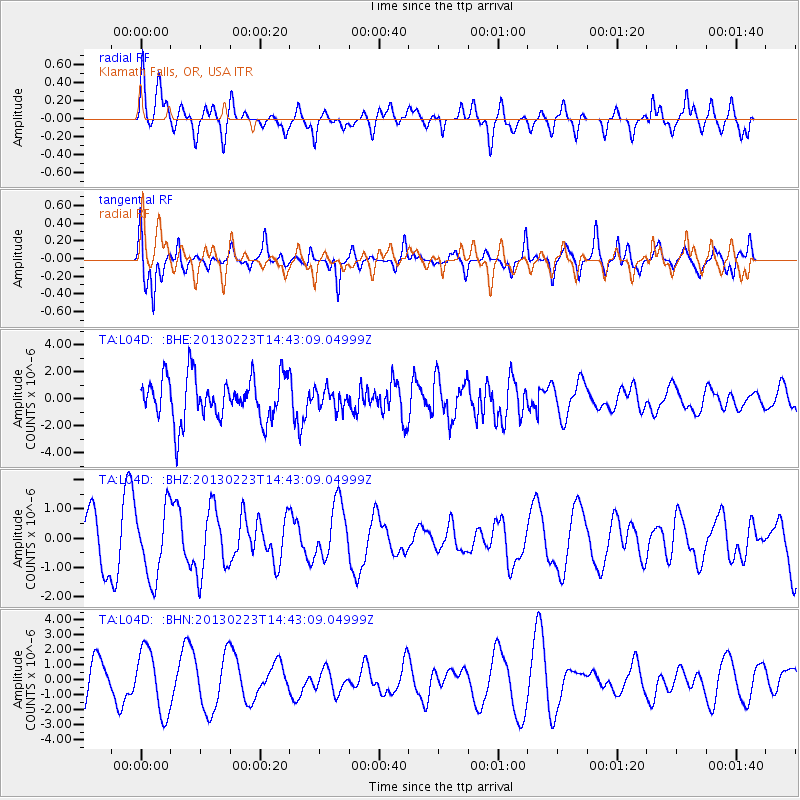
L04D Klamath Falls, OR, USA - Earthquake Result Viewer
*The percent match for this event was below the threshold and hence no stack was calculated.
| Earthquake location: |
Santa Cruz Islands |
| Earthquake latitude/longitude: |
-11.7/165.0 |
| Earthquake time(UTC): |
2013/02/23 (054) 14:31:03 GMT |
| Earthquake Depth: |
10 km |
| Earthquake Magnitude: |
5.6 MB, 5.3 MS, 5.6 MW, 5.6 MW |
| Earthquake Catalog/Contributor: |
WHDF/NEIC |
|
| Network: |
TA USArray Transportable Network (new EarthScope stations) |
| Station: |
L04D Klamath Falls, OR, USA |
| Lat/Lon: |
42.22 N/122.30 W |
| Elevation: |
1437 m |
|
| Distance: |
85.3 deg |
| Az: |
45.358 deg |
| Baz: |
249.757 deg |
| Ray Param: |
$rayparam |
*The percent match for this event was below the threshold and hence was not used in the summary stack. |
|
| Radial Match: |
47.221085 % |
| Radial Bump: |
400 |
| Transverse Match: |
67.09627 % |
| Transverse Bump: |
357 |
| SOD ConfigId: |
494114 |
| Insert Time: |
2013-05-09 05:39:49.732 +0000 |
| GWidth: |
2.5 |
| Max Bumps: |
400 |
| Tol: |
0.001 |
|
Signal To Noise
| Channel | StoN | STA | LTA |
| TA:L04D: :BHZ:20130223T14:43:09.04999Z | 1.8575591 | 1.1905444E-6 | 6.409187E-7 |
| TA:L04D: :BHN:20130223T14:43:09.04999Z | 2.0763342 | 2.114895E-6 | 1.0185717E-6 |
| TA:L04D: :BHE:20130223T14:43:09.04999Z | 0.4443006 | 7.144551E-7 | 1.6080445E-6 |
| Arrivals |
| Ps | |
| PpPs | |
| PsPs/PpSs | |


