You are here: Home > Network List > UW - Pacific Northwest Regional Seismic Network Stations List
> Station UMAT Pilot Rock, OR, USA > Earthquake Result Viewer
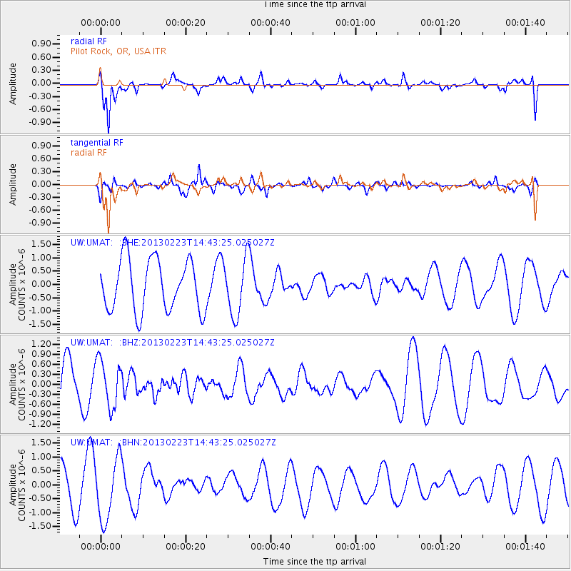
UMAT Pilot Rock, OR, USA - Earthquake Result Viewer
*The percent match for this event was below the threshold and hence no stack was calculated.
| Earthquake location: |
Santa Cruz Islands |
| Earthquake latitude/longitude: |
-11.7/165.0 |
| Earthquake time(UTC): |
2013/02/23 (054) 14:31:03 GMT |
| Earthquake Depth: |
10 km |
| Earthquake Magnitude: |
5.6 MB, 5.3 MS, 5.6 MW, 5.6 MW |
| Earthquake Catalog/Contributor: |
WHDF/NEIC |
|
| Network: |
UW Pacific Northwest Regional Seismic Network |
| Station: |
UMAT Pilot Rock, OR, USA |
| Lat/Lon: |
45.29 N/118.96 W |
| Elevation: |
1318 m |
|
| Distance: |
88.6 deg |
| Az: |
43.25 deg |
| Baz: |
251.951 deg |
| Ray Param: |
$rayparam |
*The percent match for this event was below the threshold and hence was not used in the summary stack. |
|
| Radial Match: |
70.1556 % |
| Radial Bump: |
400 |
| Transverse Match: |
73.31455 % |
| Transverse Bump: |
400 |
| SOD ConfigId: |
494114 |
| Insert Time: |
2013-05-09 05:40:28.519 +0000 |
| GWidth: |
2.5 |
| Max Bumps: |
400 |
| Tol: |
0.001 |
|
Signal To Noise
| Channel | StoN | STA | LTA |
| UW:UMAT: :BHZ:20130223T14:43:25.025027Z | 1.304893 | 6.9310767E-7 | 5.3116054E-7 |
| UW:UMAT: :BHN:20130223T14:43:25.025027Z | 1.7345427 | 1.1145457E-6 | 6.4255886E-7 |
| UW:UMAT: :BHE:20130223T14:43:25.025027Z | 1.0991055 | 1.0624841E-6 | 9.666807E-7 |
| Arrivals |
| Ps | |
| PpPs | |
| PsPs/PpSs | |


